The introductions of the country, dependency and region entries are in the native languages and in English. The other introductions are in English.
| |
|
Atlas-country
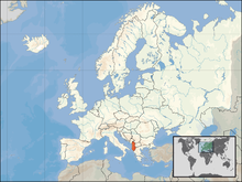
|
Albania
|
|
|
|
|
|
|
|
Shqipëria
|
|
|
|
| Shqip
|
Shqipëria - Republika e Shqipërisë
Shqipëria është një vend mesdhetar i cili shtrihet në juglindje të Evropës, në perëndim të Gadishullit Ballkanik, me koordinatat gjeografike: 41°19'39" gjerësi veriore dhe 19°49'8" gjatësi lindore. Shqipëria ka një sipërfaqe prej 28.748 km².
|
| English
|
Albania - Republic of Albania
The Republic of Albania is a Balkan country in Southeastern Europe. It borders ► Montenegro to the north, ► Kosovo to the northeast, the ► Republic of Macedonia in the east, and ► Greece in the south. It has a coast on the Adriatic Sea to the west and a coast on the Ionian Sea to the southwest.
|
|
|
|
| Short name
|
Albania
|
| Official name
|
Republic of Albania
|
| Status
|
Independent country since 1912
|
| Location
|
South-East Europe
|
| Capital
|
Tiranë (Tirana)
|
| Population
|
2,845,955 inhabitants
|
| Area
|
28,748 square kilometres (11,100 sq mi)
|
| Major languages
|
Albanian (official)
|
| Major religions
|
Islam, Eastern Orthodoxy, Roman Catholicism
|
| More information
|
Albania, Geography of Albania, History of Albania and Politics of Albania
|
| More images
|
Albania - Albania (Category).
|
|
General maps

|
Map of Albania
|

|
Map of Albania
|

|
Shaded relief map of Albania
|

|
Topographic map of Albania
|

|
Flag map of Albania
|

|
Blank map of Albania
|

|
Blank map of Albania
|

|
Road map of Albania
|
History maps
This section holds a short summary of the history of the area of present-day Albania, illustrated with maps, including historical maps of former countries and empires that included present-day Albania.

|
Illyrian migration
|

|
Illyrian ethnogenesis
|

|
Prehistoric Illyrian sites and cultures
|

|
Prehistoric Illyrian sites and cultures
|

|
Iron Age Glasinac culture (around 300 BC)
|

|
Ethnic territory of the Illyrians and Illyrian tribes (8th-3rd century BC)
|

|
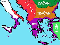
Illyrians in the Balkans and Italy in 550 BC
|
|
Illyrians in the Balkans and Italy in 550 BC
|

|
Map of Dionysius of Syracuse's military attempts to place Alcetas in the throne of the Molossians (385 BC) - army of Illyrian / Dardanian king Bardyllis also participated in this military intervention
|

|
Illyrian tribes in the Balkans and Italy prior to Roman conquest
|

|
Illyrians, Illyria Barbara, Illyria Graeca, Illyrians Proper and Environs
|
|
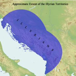
Approximate extent of the Illyrian territories prior to Roman conquest
|

|
Illyrian tribes in the Balkans and Italy prior to Roman conquest
|

|
Illyrian tribes in the Balkans and Italy prior to Roman conquest
|

|
Illyrian tribes in the Balkans
|

|
Illyrians in the Balkans prior to Roman conquest
|

|
(svg) Illyrians proper prior to Roman conquest
|

|
Illyrian tribes and cities in the southern Balkans (4th century BC)
|

|
(svg) Illyrian tribes and cities in the southern Balkans (4th century BC)
|

|
Illyrian Kingdom of Agron (250 BC - 230 BC)
|

|
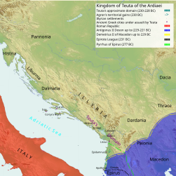
Illyrian Kingdom of Teuta (230 - 228 BC)
|

|
228 BC Adriatic Coast)
|

|
228 BC Illyrian & Dardanian Kingdoms)
|

|
230 BC Adriatic Coast)
|

|
230 BC Illyrian & Dardanian Kingdoms)
|
|
230-228 BC Teuta's Kingdom)
|

|
228-220 BC Roman Client state governed by Demetrius of Pharos)
|

|
237 BC Adriatic Coast)
|

|
250-230 BC Agron's Kingdom)
|

|
Illyrian kingdoms of Illyria and Dardania (3rd century BC, around 230 BC)
|

|
Roman Client state governed by Demetrius of Pharos (228 - 220 BC)
|

|
Roman protectorate in 200 BC
|
| [[|border|251x400px]]
|
Illyrian Kingdom of Gentius (181 BC - 167 BC)
|

|
Ancient Illyria during Third Macedonian War, 2nd century BC
|

|
Ancient Greek settlements in Albania
|

|
Territorial development of the Roman Empire 264 BC-192, including the conquest of present-day Albania
|
|
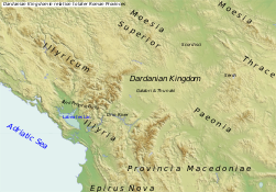
Dardanian Kingdom in relation to later Roman Provinces
|

|
Illyrian tribes in the Balkans in 6 AD
|

|
Great Illyrian uprising, 6-9 AD
|

|
Illyrian uprising in 6 AD
|

|
Illyrian uprising in 7 AD
|

|
Illyrian uprising in 8 AD
|

|
Illyrian uprising in 9 AD
|

|
The extent of the Roman Republic and Roman Empire; 44 BC (late Republic, after conquests by republican generals) AD 14 (death of Augustus) |

|
Roman province of Illyricum
|

|
Roman provinces of Illyricum and Macedonia
|

|
The location of the Albani (Albanoi) tribe 150 AD in the Roman province of Macedon, Albanopolis may have been in the same location
|

|
Albani tribe (located on the bottom left on the map)
|

|
Roman Balkans, the Albani appear at 150 AD
|

|
Roman province of Epirus Nova (Illyria Graeca), 3rd-4th century
|

|
(svg) Roman province of Epirus Nova (Illyria Graeca), 3rd-4th century
|
|
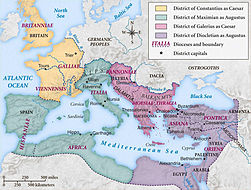
Territory of emperor Galerius during the Tetrarchy
|

|
Roman prefecture of Illyricum, 4th century
|

|
Roman prefecture of Illyricum, 4th century
|

|
Roman prefecture of Illyricum, 4th century
|

|
Roman dioceses of Macedonia and Dacia
|

|
The division of the Empire after the death of Theodosius I, ca.395 AD superimposed on modern borders.
|

|
Division of the Roman Empire in 406
|

|
Invasions of the Roman Empire 100-500
|
|
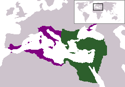
Eastern Roman Empire
|

|
Eastern Roman Empire under emperor Justinianus
|

|
Eastern Roman Empire under emperor Justinianus
|

|
Albanians in the 5th-10th century
|

|
Map of the changes in borders of the Byzantine Empire
|

|
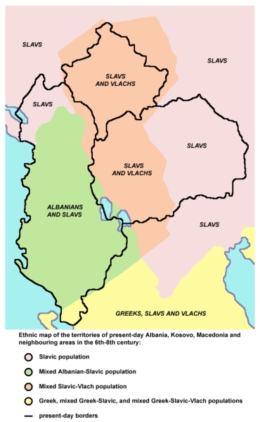
Ethnic Albanians in the Balkans, 6th-8th century (according to the historical atlas for schools, published in Belgrade in 1970, representing a view of Yugoslav historians from that time)
|

|
Ethnic Albanians in the Balkans, 7th-8th century
|

|
The Byzantine Empire at the accession of Basil I, c. 867
|

|
Devol province of the Bulgarian Empire (9th-10th century) and Great Devol province (11th-12th century)
|

|
The Byzantine Empire under Basil II, c. 1025
|

|
Byzantine Empire 1025
|

|
Map of the Byzantine Empire under Manuel Komnenos, c.1170.
|

|
Byzantine Empire 1180
|
|
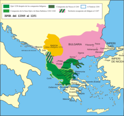
The despotate of Epirus from 1230 to 1251
|

|
The Byzantine Empire and Despotate of Epirus in 1265 (William R. Shepherd, Historical Atlas, 1911).
|

|
Byzantine Empire and Despotate of Epirus in 1265
|

|
The despotate of Epirus from 1252 to 1315 and Kingdom of Albania (Regnum Albaniae) under Anjou rule in 1272
|

|
Albanian (& Vlach) migrations in 1300-1350 AD at Epirus Nova
|
|
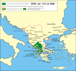
The despotate of Epirus from 1315 to 1358 and Serbian Empire of Stefan Dušan
|

|
Serbian Empire of Stefan Dušan in 1355
|

|
Map of the Serbian Empire in 1360 with territories ruled by Albanian local rulers - Karl Topia, Peter Losha and Gjin Bua Spata
|

|
Empire of the Romans (Greeks) and Serbs and whole Albania (Empire of Simeon Uroš - Siniša), 14th century
|

|
Territory of Albanian local rulers after the collapse of the Serbian Empire in the second half of the 14th century
|
|
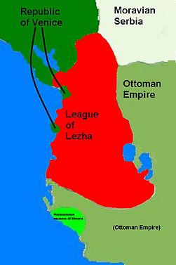
League of Lezhë - Albanian state under Skanderbeg in 1444–1479
|

|
Albanian state under Skanderbeg in 1449
|

|
Venetian possessions in northern Albania in 1448
|

|
Venetian possessions in northern Albania in 1448
|

|
Growth of the Ottoman Empire
|

|
Development of the European part of the Ottoman Empire
|

|
Growth of the Ottoman Empire
|

|
Location of the Ottoman Empire in 1683
|

|
Balkans after 1856
|

|
Albanian vilayet, proposed by the League of Prizren in 1878
|
|
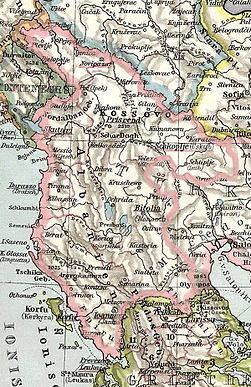
Albanian vilayet, proposed by the League of Prizren in 1878
|

|
Albanian vilayet, proposed by the League of Prizren in 1878
|

|
Ottoman provinces in the Balkans in 1905
|

|
Independent Albania in 1912-1913; territories under Albanian de facto control
|

|
Independent Albania in 1912-1913; territories recognized as parts of Albanian state
|

|
Independent Albania in 1912-1913; territories recognized as parts of Albanian state
|

|
Serbian occupation of Albania in 1912
|
|
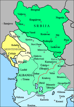
Serbian occupation of Albania in 1913
|
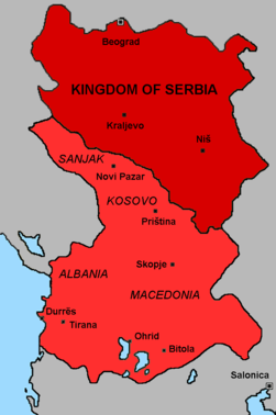
|
Serbian occupation of Albania in 1913
|

|
Albania in 1913
|

|
Albania in 1917
|

|
North Albania in 1918
|

|
Albania in 1920
|

|
Greek counteroffensive in 1940
|

|
Greek counteroffensive in 1940
|

|
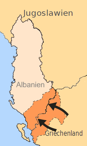
Greek occupation of south Albania, November 1940 - March 1941
|

|
Greater Albania in 1941
|

|
Greater Albania in 1941
|

|
Greater Albania in 1941-1944
|

|
Greater Albania in 1942
|

|
Greater Albania in 1942
|

|
Balkanic federation whose creation was proposed after World War II
|

|
Albania, 1946-1991
|

|
Kosovo refugees in Albania in 1999
|

|
Map of Albania and bordering countries from 2003 to 2006
|
Ethnic, linguistic and religion maps

|
Ethnic map (1861)
|

|
Ethnic map (1877)
|
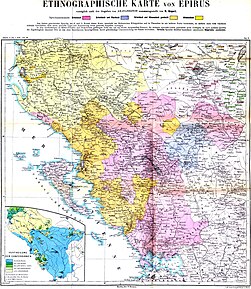
|
Ethnographic map of the Epirus region, 1878. Greek point of view
|
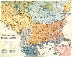
|
Ethnic map (1880)
|

|
Peoples at the Balkan Peninsula, Andrees Allgemeiner Handatlas, 1st Edition, Leipzig (Germany) 1881
|

|
Ethnic map of the Southwestern Balkan Peninsula (1890)
|

|
Ethnic map (1898)
|

|
Ethnic map (1898)
|

|
Vlachs in Albania at the beginning of the XX century
|

|
Ethnic map (1911)
|

|
Ethnic map of the Balkans (1923)
|

|
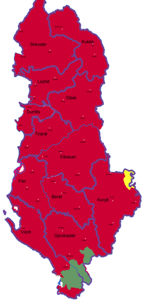
Ethnic composition of Albania, municipality data of 1989 census
|

|
Distribution of Albanians outside Albania
|
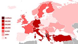
|
Albanians in Europe
|

|
Number of Albanians by state
|

|
The distribution of Haplogroup E-V13 in Europe
|
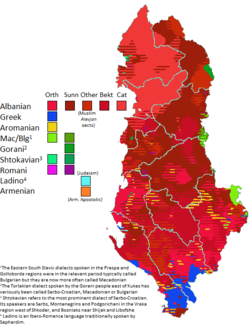
|
Traditional linguistic and religious communities in Albania
|
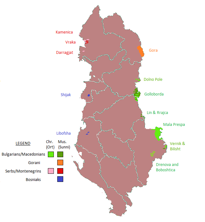
|
thumb
|

|
Gora Region between Kosovo and Albania
|

|
Vlachs in Albania
|

|
Albanian dialects
|

|
Albanian dialects
|
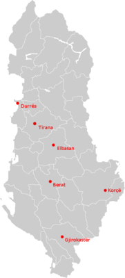
|
Orthodox Dioceses in Albania
|

|
Roman Catholic Dioceses in Albania
|
Other maps

|
The Swine flu spread in Albania, as of July, 25th, 2009
|
Politics

|
Map of proposed Greater Albania
|

|
Map of proposed Greater Albania
|

|
Presence of Albanians in proposed Greater Albania
|
Old maps

|
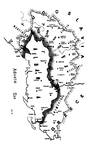
North Albania in 1918
|
Satellite maps
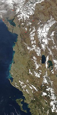
|
Satellite map
|
Districts of Albania
-
Berat
-
Bulqize
-
Delvine
-
Devoll
-
Diber
-
Durres
-
Elbasan
-
Fier
-
Gjirokaster
-
Gramsh
-
Has
-
Kavaje
-
Kolonie
-
Korce
-
Kruje
-
Kocove
-
Kukes
-
Kurbin
-
Lezhe
-
Librazhd
-
Malesi e Madhe
-
Mallakaster
-
Mat
-
Mirdite
-
Peqin
-
Permet
-
Pogradec
-
Puke
-
Sarande
-
Shkoder
-
Skrapar
-
Tepelene
-
Tirane
-
Tropoje
-
Vlore
Notes and references
General remarks:
- The WIKIMEDIA COMMONS Atlas of the World is an organized and commented collection of geographical, political and historical maps available at Wikimedia Commons. The main page is therefore the portal to maps and cartography on Wikimedia. That page contains links to entries by country, continent and by topic as well as general notes and references.
- Every entry has an introduction section in English. If other languages are native and/or official in an entity, introductions in other languages are added in separate sections. The text of the introduction(s) is based on the content of the Wikipedia encyclopedia. For sources of the introduction see therefore the Wikipedia entries linked to. The same goes for the texts in the history sections.
- Historical maps are included in the continent, country and dependency entries.
- The status of various entities is disputed. See the content for the entities concerned.
- The maps of former countries that are more or less continued by a present-day country or had a territory included in only one or two countries are included in the atlas of the present-day country. For example the Ottoman Empire can be found in the Atlas of Turkey.
|
Entries available in the atlas
- General pages
- World
- Continents and oceans
- Themes
- Historical eras
- States with wide recognition
- States with limited recognition
- Dependencies and other overseas territories
- Country subdivisions
- Belgium
- China (mainland)
- India
- Pakistan
- Spain
- United Kingdom
- United States
- Russia
- Other
- Disputed subnational territories
- Other regions
- Cities
- Former sovereign states
- Former dependencies and overseas territories
- Former disputed territories
|


