The introductions of the country, dependency and region entries are in the native languages and in English. The other introductions are in English.
| |
|
Atlas-country

|
Bangladesh
|
|
|
|
|
|
|
|
বাংলাদেশ
|
|
|
|
| বাংলা
|
বাংলাদেশ - গণপ্রজাতন্ত্রী বাংলাদেশ
গণপ্রজাতন্ত্রী বাংলাদেশ দক্ষিণ এশিয়ার একটি রাষ্ট্র। দেশটির উত্তর, পূর্ব ও পশ্চিম সীমানায় ভারত ও দক্ষিণ-পূর্ব সীমানায় মিয়ানমার; দক্ষিণে বঙ্গোপসাগর। বাংলাদেশ ও ভারতীয় অঙ্গরাজ্য পশ্চিমবঙ্গ একত্রে একটি বাংলাভাষী অঞ্চল গঠন করেছে, যার ঐতিহাসিক নাম “বঙ্গ” বা “বাংলা”।
|
| English
|
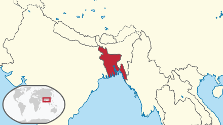
Bangladesh - People's Republic of Bangladesh
The People's Republic of Bangladesh, is a country in South Asia and converges with South-east Asia. It is surrounded by ► India on all sides except for a small border with ► Myanmar to the far southeast and the Bay of Bengal to the south. Together with the Indian state of West Bengal, it makes up the ethno-linguistic region of Bengal. The name Bangladesh means "Country of Bengal".
|
|
|
|
| Short name
|
Bangladesh
|
| Official name
|
People's Republic of Bangladesh
|
| Status
|
Independent country since 1971
|
| Location
|
South Asia
|
| Capital
|
ঢাকা (Dhaka)
|
| Population
|
144,043,697 inhabitants
|
| Area
|
148,460 square kilometres (57,320 sq mi)
|
| Major languages
|
Bengali (official)
|
| Major religions
|
Islam, Hinduism
|
| More information
|
Bangladesh, Geography of Bangladesh, History of Bangladesh and Politics of Bangladesh
|
| More images
|
Bangladesh - Bangladesh (Category).
|
|
General maps

|
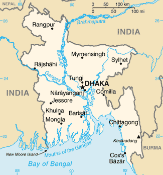
Map of Bangladesh
|
Maps of divisions
This section holds maps of the administrative divisions.

|
Administrative divisions of Bangladesh
|

|
Divisions of Bangladesh in Bengali
|
-
Districts of Dhaka
-
Districts of Chittagong
-
Districts of Rajshahi
History maps
This section holds a short summary of the history of the area of present-day Bangladesh, illustrated with maps, including historical maps of former countries and empires that included present-day Bangladesh.

|
Maurya and Gupta Empires
|

|
Mauryan Empire
|

|
Gupta Empire
|

|
Gupta Empire
|

|
Gupta Empire
|

|
European settlements in India 1501-1739
|

|
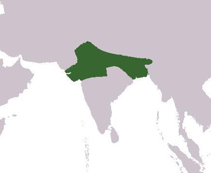
Mughal Empire
|

|
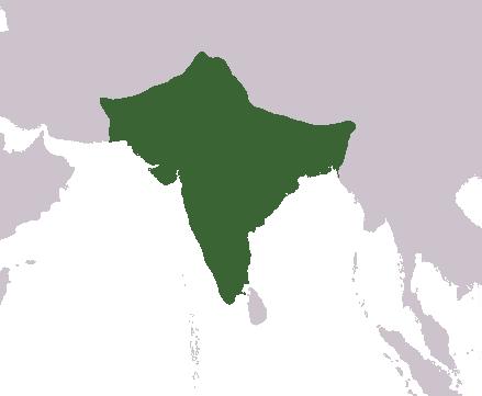
India 1700-1792
|

|
British India, not including Burma
|

|
Partition of India
|

|
Bangladesh liberation war 1971
|

|
Bangladesh liberation war sectors, 1971
|

|
Divisions 1971-1993
|

|
Divisions 1993-1998
|

|
Divisions 1998-2010
|
Old maps
This section holds copies of original general maps more than 70 years old.

|
Map of Bengal from 1776
|

|
Hindustan in 1812 by Arrowsmith and Lewis
|

|
Map of Bengal 1893
|

|
Map of Eastern Bengal and Assam 1907
|
Ethno-linguistic maps

|
Languages of Bangladesh
|

|
Languages of South Asia
|

|
Indo-Aryan languages
|

|
The Bengali language
|
Other maps

|
Rail and road map
|
Satellite maps

|
Satellite image of Bangladesh in October 2001
|
Notes and references
General remarks:
- The WIKIMEDIA COMMONS Atlas of the World is an organized and commented collection of geographical, political and historical maps available at Wikimedia Commons. The main page is therefore the portal to maps and cartography on Wikimedia. That page contains links to entries by country, continent and by topic as well as general notes and references.
- Every entry has an introduction section in English. If other languages are native and/or official in an entity, introductions in other languages are added in separate sections. The text of the introduction(s) is based on the content of the Wikipedia encyclopedia. For sources of the introduction see therefore the Wikipedia entries linked to. The same goes for the texts in the history sections.
- Historical maps are included in the continent, country and dependency entries.
- The status of various entities is disputed. See the content for the entities concerned.
- The maps of former countries that are more or less continued by a present-day country or had a territory included in only one or two countries are included in the atlas of the present-day country. For example the Ottoman Empire can be found in the Atlas of Turkey.
|
Entries available in the atlas
- General pages
- World
- Continents and oceans
- Themes
- Historical eras
- States with wide recognition
- States with limited recognition
- Dependencies and other overseas territories
- Country subdivisions
- Belgium
- China (mainland)
- India
- Pakistan
- Spain
- United Kingdom
- United States
- Other
- Disputed subnational territories
- Other regions
- Cities
- Former sovereign states
- Former dependencies and overseas territories
- Former disputed territories
References
|