File:Aegean Sea map bathymetry.svg
Jump to navigation
Jump to search

Size of this PNG preview of this SVG file: 493 × 599 pixels. Other resolutions: 197 × 240 pixels | 395 × 480 pixels | 631 × 768 pixels | 842 × 1,024 pixels | 1,684 × 2,048 pixels | 3,750 × 4,560 pixels.
Original file (SVG file, nominally 3,750 × 4,560 pixels, file size: 3.54 MB)
Captions
Captions
Add a one-line explanation of what this file represents
Summary
[edit]| Description |
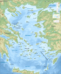
Français : Carte topographique et bathymétrique de la Mer Égée. |
| Date | |
| Source | File:Aegean Sea map bathymetry-fr.svg |
| Author | Eric Gaba – Sting |
| Other versions |
[]
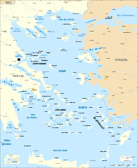
Same map but full SVG and without relief and bathymetry:
|


Licensing
[edit]This file is licensed under the Creative Commons Attribution-Share Alike 4.0 International license.
- You are free:
- to share – to copy, distribute and transmit the work
- to remix – to adapt the work
- Under the following conditions:
- attribution – You must give appropriate credit, provide a link to the license, and indicate if changes were made. You may do so in any reasonable manner, but not in any way that suggests the licensor endorses you or your use.
- share alike – If you remix, transform, or build upon the material, you must distribute your contributions under the same or compatible license as the original.
File history
Click on a date/time to view the file as it appeared at that time.
| Date/Time | Thumbnail | Dimensions | User | Comment | |
|---|---|---|---|---|---|
| current | 20:20, 28 April 2023 | 3,750 × 4,560 (3.54 MB) | GrandEscogriffe (talk | contribs) | Uploaded a work by Eric Gaba – {{u|Sting}} from File:Aegean Sea map bathymetry-fr.svg with UploadWizard |
You cannot overwrite this file.
File usage on Commons
The following 13 pages use this file:
- Aegean Sea
- File:Aegean Sea map-de.png
- File:Aegean Sea map-de.svg
- File:Aegean Sea map-fr.svg
- File:Aegean Sea map-it.svg
- File:Aegean Sea map bathymetry-fi.svg
- File:Aegean Sea map bathymetry-fr.jpg
- File:Aegean Sea map bathymetry-fr.svg
- File:Aegean Sea map bathymetry-it.svg
- File:Aegean Sea map bathymetry.svg
- Template:Other versions/Aegean Sea map bathymetry
- Category:Aegean Sea
- Category:Views from Cape Sounion
File usage on other wikis
The following other wikis use this file:
- Usage on fr.wikipedia.org
- Usage on www.wikidata.org