Kamenz (district)
Kamenz | |
|---|---|
 | |
| Coordinates: 51°16′00″N 14°06′00″E / 51.2667°N 14.1000°E | |
| Country | Germany |
| State | Saxony |
| Adm. region | Dresden |
| Disbanded | 2008 |
| Capital | Kamenz |
| Area | |
| • Total | 1,340.34 km2 (517.51 sq mi) |
| Population (2001) | |
| • Total | 154,954 |
| • Density | 120/km2 (300/sq mi) |
| Time zone | UTC+01:00 (CET) |
| • Summer (DST) | UTC+02:00 (CEST) |
| Vehicle registration | KM |
| Website | http://www.lra-kamenz.de |
Kamenz (Sorbian languages: Kamjenc) was a Landkreis (rural district) in the north-east of the Free State of Saxony, Germany. The independent city Hoyerswerda is completely surrounded by the district. There was a reorganisation of districts in Saxony in July 2008, and Hoyerswerda became a part of Landkreis Kamenz instead of having a separate government.
History
[change | change source]The district was formed in 1994 from the previous Kamenz district, the northern parts of the Dresden-Land district, around Radeberg, and the Hoyerswerda district, except the town of Hoyerswerda, which became a district-free city. From 1994 to 1996 it was called Westlausitz - Dresdner Land, but then renamed to Kamenz again.
Partnerships
[change | change source]Since December 14, 1990 the district has been a twin town of the district Alzey-Worms in Rhineland-Palatinate.
Coat of arms
[change | change source] |
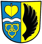
The colours of the coat of arms are those of the Upper Lusatia. The black wing on the right side is the symbol of the Lords (German: Herr) of Kamenz. The linden leaf in the top of the left half stands for the Sorbian minority. The wavy line below symbolizes the three rivers Röder, Elster and Spree. The three rings in the bottom symbolize the joining together of the three old districts. The symbol was taken from the play "Nathan der Weise" by Lessing. |
Towns and municipalities
[change | change source]| Towns | Municipalities | |
|---|---|---|
References
[change | change source]
Other websites
[change | change source]- Official website Archived 2014-12-21 at the Wayback Machine (German)
