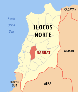
Sarrat
Appearance
| Sarrat | |
|---|---|
| Baley na Filipinas | |
 | |
 Lokasyon na Sarrat | |
 | |
| 18°9′28″N 120°38′41″E | |
| Dalin | Filipinas |
| Barangay | 24 |
| Kaawang | |
| • Katiponan | 57.39 km2 (22.16 sq mi) |
| Elebasyon | 49 m (161 ft) |
| Bilang na too (Mayo 1, 2020)[1] | |
| • Katiponan | 25,186 |
| • Densidad | 440/km2 (1,100/sq mi) |
| Economia | |
| • Clase | kumapat ya klase ya baley |
| • Ingresos | ₱130,473,761.5682,822,557.6967,260,518.4867,632,537.2284,143,371.02114,272,699.93110,188,757.20164,948,421.40104,231,737.64175,250,544.90209,841,831.17 (2020) |
| • Activos | ₱522,361,653.6716,747,193,868.00188,445,044.55198,708,333.49229,653,408.90320,549,955.90370,832,296.13457,949,804.61476,191,901.13567,556,244.04677,293,769.82 (2020) |
| • Pasivos | ₱53,522,618.9637,816,399.0225,638,583.7638,223,182.4844,226,594.5650,565,290.7355,521,389.4360,461,330.3950,905,654.0434,760,654.3955,964,767.62 (2020) |
| • Gastos | ₱100,702,539.4341,051,326.851,856,613.95881,091.5356,645,871.9963,825,785.7864,585,101.5676,686,076.7389,635,997.88117,028,975.38122,609,330.69 (2020) |
| Kodigo na postal | 2914 |
| Kodigo na lugar | 77 |
Say Sarrat et kumapat ya klase ya baley ed luyag na Ilocos ed Baybay, Filipinas. Unong ed 1 Mayo 2020 census, say populasyon to et 25,186 totoo tan 6,442 abong. Walay kabaleg tan sukat to ya 57.39 sq. km. Say zip code to et 2914.
Saray barangay
[dumaen | dumaen so pinanlapuan]- San Agustin (Pob.)
- San Andres
- San Antonio
- San Bernabe
- San Cristobal
- San Felipe
- San Francisco (Pob.)
- San Isidro
- San Joaquin (Pob.)
- San Jose
- San Juan
- San Leandro (Pob.)
- San Lorenzo
- San Manuel
- San Marcos
- San Nicolas
- San Pedro
- San Roque
- San Vicente (Pob.)
- Santa Barbara (Pob.)
- Santa Magdalena
- Santa Rosa
- Santo Santiago
- Santo Tomas
Demograpiko
[dumaen | dumaen so pinanlapuan]| Taon | Pop. | ±% p.a. |
|---|---|---|
| 1903 | 9,584 | — |
| 1918 | 12,885 | +1.99% |
| 1939 | 14,430 | +0.54% |
| 1948 | 14,345 | −0.07% |
| 1960 | 15,136 | +0.45% |
| 1970 | 16,847 | +1.08% |
| 1975 | 18,071 | +1.42% |
| 1980 | 18,798 | +0.79% |
| 1990 | 21,272 | +1.24% |
| 1995 | 21,301 | +0.03% |
| 2000 | 22,886 | +1.55% |
| 2007 | 23,810 | +0.55% |
| 2010 | 24,770 | +1.45% |
| 2015 | 25,212 | +0.34% |
| 2020 | 25,186 | −0.02% |
| Reperensiya: Philippine Statistics Authority[2][3][4] | ||
Saray reperensiya
[dumaen | dumaen so pinanlapuan]- ↑ "2020 Census of Population and Housing (2020 CPH) Population Counts Declared Official by the President". Hulyo 7, 2021. https://psa.gov.ph/content/2020-census-population-and-housing-2020-cph-population-counts-declared-official-president.
- ↑ Census of Population (2015). "Region I (Ilocos Region)". Total Population by Province, City, Municipality and Barangay. PSA. Retrieved 29 June 2016.
- ↑ Census of Population and Housing (2010). "Region I (Ilocos Region)". Total Population by Province, City, Municipality and Barangay. NSO. Retrieved 29 June 2016.
- ↑ Censuses of Population (1903–2007). "Region I (Ilocos Region)". Table 1. Population Enumerated in Various Censuses by Province/Highly Urbanized City: 1903 to 2007. NSO.