[go: up one dir, main page]

Vai al contenuto

File:NS administrative Gliederung 1944.png

Contenuti della pagina non supportati in altre lingue.
File proveniente da Wikimedia Commons. Clicca per visitare la pagina originale
Da Wikipedia, l'enciclopedia libera.

File originale (8 000 × 6 094 pixel, dimensione del file: 4,14 MB, tipo MIME: image/png)

Logo di Commons
Logo di Commons
Questo file e la sua pagina di descrizione (discussione · modifica) si trovano su Wikimedia Commons (?)
Questa immagine (categorizzazione automatica: locator map) o tutte le immagini in questa categoria o galleria dovrebbero essere ricreate usando grafica vettoriale come file SVG. Questo offre diversi vantaggi: vedi Commons:Media for cleanup per maggiori informazioni. Se è disponibile una versione in formato SVG di questa immagine, per favore caricala. Dopo aver caricato un file SVG, sostituisci questo avviso con il template {{Vector version available|nome_immagine.svg}}.

Dettagli

Descrizione
Беларуская (тарашкевіца): Мапа адміністрацыйна-тэрытарыяльнага падзелу Вялікага нямецкага райху паводле НСДАП (1944).
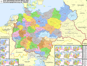
Deutsch: Karte der Verwaltungsgliederung des Großdeutschen Reiches durch die NSDAP 1944. Sie zeigt die Kreise, Gaue und Reichsgaue der NSDAP. Zudem die Länder, die Gebiete der Reichsstatthalter und die Rechtsstellung der Reichsteile. Zusätzlich Postleitzahlen, Kennzeichen, Wehrkreise, Oberlandesgerichte, Staatspolizeistellen, Direktionen der Reichsbahn, Oberste Bauleitung der Reichsautobahnen und Arbeitsamtsgebiete 1944.
English: Map of the administrative division of the Greater German Reich (»Großdeutsches Reich«/»Großdeutschland«/"Greater German Empire"/"Greater Germany") by the NSDAP (Nazi Party) 1944, showing Kreise, Gaue and Reichsgaue. In addition, the states, the territories of the Reichsstatthalter and the legal status of Reich territories. Additionally postal codes, license plates, military districts, higher regional courts, State Police offices, railway directorates, Supreme construction management of the highways and work coordination areas 1944.
Polski: Mapa Wielkiej Rzeszy Niemieckiej (1944)
Русский: Административно-территориальное деление Третьего Рейха - Великой Германии (1944)
Українська: Адміністративно-територіальний поділ Третього Рейху - Великої Німеччини (1944)
Data
Fonte Opera propria
Autore Bennet Schulte
Licenza
(Riusare questo file)

Diese Datei habe ich als Urheber Bennet Schulte unter der CC-BY-SA-3.0-DE in der Wikipedia veröffentlicht. Dies bedeutet, dass eine kostenlose, auch kommerzielle Nutzung außerhalb der Wikipedia unter folgenden Bedingungen möglich ist:

  • Online-Medien:
    1. Als Urheber wird „Bennet Schulte/Wikipedia“ genannt.
    2. Es wird ein Link auf die Originaldatei gesetzt: //commons.wikimedia.org/wiki/File:NS_administrative_Gliederung_1944.png
    3. Eine Kopie des Lizenzvertrags auf Ihrer Seite oder die vollständige Internetadresse (https://creativecommons.org/licenses/by-sa/3.0/de/legalcode) zum Lizenzvertrag am Bild
  • Print-Medien:
    1. Als Urheber wird „Bennet Schulte/Wikipedia“ genannt.
    2. Eine Kopie des Lizenzvertrags oder die vollständige Internetadresse (https://creativecommons.org/licenses/by-sa/3.0/de/legalcode) zum Lizenzvertrag an der Datei

Ich bitte um Zusendung eines Belegexemplares bzw. der URL, unter der die Datei benutzt wird.

Bitte schreiben Sie eine E-Mail an wikimap[at]benneten.de, wenn Sie

  • meine Adresse für die Zusendung eines Belegexemplares benötigen,
  • weitergehende Fragen zur Lizenznutzung haben.

PS: Wenn jedoch Nutzer diese Lizenz nicht erfüllen, beanspruche ich als Urheber für die Verwertung meiner Leistung vergütet zu werden.

I have published this file as author Bennet Schulte under the "CC-BY-SA-3.0-DE" in Wikipedia. This means that free, commercial usage outside of Wikipedia is permitted under the following licence terms:

Please send me a specimen copy or the URL of the website where the file is used.

Please write an email to wikimap[at]benneten.de if you

  • need my postal address for sending a specimen copy
  • have further questions about the terms of the licence

PS: In case of refusal of the above terms the author reserves the right to take legal action.

w:it:Creative Commons
attribuzione condividi allo stesso modo
Questo file è disponibile in base alla licenza Creative Commons Attribuzione-Condividi allo stesso modo 3.0 Germania.
Tu sei libero:
  • di condividere – di copiare, distribuire e trasmettere quest'opera
  • di modificare – di adattare l'opera
Alle seguenti condizioni:
  • attribuzione – Devi fornire i crediti appropriati, un collegamento alla licenza e indicare se sono state apportate modifiche. Puoi farlo in qualsiasi modo ragionevole, ma non in alcun modo che suggerisca che il licenziante approvi te o il tuo uso.
  • condividi allo stesso modo – Se remixi, trasformi o sviluppi il materiale, devi distribuire i tuoi contributi in base alla stessa licenza o compatibile all'originale.
Altre versioni
Annotazioni
InfoField
Questa immagine è annotata: Vedi le annotazioni su Commons

Didascalie

Aggiungi una brevissima spiegazione di ciò che questo file rappresenta

Elementi ritratti in questo file

raffigura

coperto da diritti d'autore<\/a>"}},"text\/plain":{"it":{"P6216":"coperto da diritti d'autore"}}}}" class="wbmi-entityview-statementsGroup wbmi-entityview-statementsGroup-P6216 oo-ui-layout oo-ui-panelLayout oo-ui-panelLayout-framed">
Creative Commons Attribution-ShareAlike 3.0 Germany<\/a>\u00a0inglese<\/sup>"}},"text\/plain":{"it":{"P275":"Creative Commons Attribution-ShareAlike 3.0 Germany"}}}}" class="wbmi-entityview-statementsGroup wbmi-entityview-statementsGroup-P275 oo-ui-layout oo-ui-panelLayout oo-ui-panelLayout-framed">
creazione originale della persona che ha caricato il file<\/a>"}},"text\/plain":{"it":{"P7482":"creazione originale della persona che ha caricato il file"}}}}" class="wbmi-entityview-statementsGroup wbmi-entityview-statementsGroup-P7482 oo-ui-layout oo-ui-panelLayout oo-ui-panelLayout-framed">

image/png

4 343 661 byte

6 094 pixel

8 000 pixel

metodo di determinazione<\/a>"}},"text\/plain":{"it":{"":"metodo di determinazione"}}},"{\"value\":{\"entity-type\":\"item\",\"numeric-id\":13414952,\"id\":\"Q13414952\"},\"type\":\"wikibase-entityid\"}":{"text\/html":{"it":{"P459":"SHA-1<\/a>"}},"text\/plain":{"it":{"P459":"SHA-1"}}}}" class="wbmi-entityview-statementsGroup wbmi-entityview-statementsGroup-P4092 oo-ui-layout oo-ui-panelLayout oo-ui-panelLayout-framed">

c28793601cbaad457870bfc5368beb17bdb66e0c

Cronologia del file

Fare clic su un gruppo data/ora per vedere il file come si presentava nel momento indicato.

(ultima | prima) Vedi (10 più recenti | ) (10 | 20 | 50 | 100 | 250 | 500).
Data/OraMiniaturaDimensioniUtenteCommento
attuale04:32, 12 ott 2021Miniatura della versione delle 04:32, 12 ott 20218 000 × 6 094 (4,14 MB)Execresolution reduzed
04:31, 12 ott 2021Miniatura della versione delle 04:31, 12 ott 202117 392 × 13 248 (4,99 MB)Exec-render modus of previous version fixed
14:09, 11 ott 2021Miniatura della versione delle 14:09, 11 ott 20218 000 × 6 094 (7,98 MB)Exec- Lublin-Galicia-Adjustment implemented, Galicia internal boundaries redone, modifications at Desitrikt Bialystok
11:36, 6 ott 2021Miniatura della versione delle 11:36, 6 ott 20218 000 × 6 094 (22,08 MB)KamilhrubCorrected name Hrubieszow and southern borders of Bilgoraj, Hrubieszow and Zamosc districts, which didn't change after 1941 (source: Amtliches Gemeinde- und Dorfverzeichnis für das Generalgouvernement auf Grund der Summarischen Bevölkerungsbestandsaufnahme am 1. März 1943)
23:27, 19 set 2021Miniatura della versione delle 23:27, 19 set 20218 000 × 6 094 (19,36 MB)Execcontent exansion on multiple aspects
23:15, 19 set 2021Miniatura della versione delle 23:15, 19 set 20218 000 × 6 094 (8,37 MB)Execinhaltliche Erweiterung verschiedenster Art
01:33, 21 feb 2021Miniatura della versione delle 01:33, 21 feb 20218 000 × 6 094 (22,22 MB)Exec- additional small map of Wehrinspektionen; minor corrections
15:57, 12 apr 2019Miniatura della versione delle 15:57, 12 apr 20198 000 × 6 094 (3,46 MB)FDRMRZUSALower resolution but better display: no more display problems and same image quality. Previous file too big: bigger dimensions not necessary. Reduced size: compressed and optimized. No other changes.
22:54, 5 giu 2018Miniatura della versione delle 22:54, 5 giu 201817 392 × 13 248 (11,47 MB)Exec- another color correction
22:33, 5 giu 2018Miniatura della versione delle 22:33, 5 giu 201817 366 × 13 226 (11,46 MB)ExecColor Error Correction
(ultima | prima) Vedi (10 più recenti | ) (10 | 20 | 50 | 100 | 250 | 500).

Utilizzo globale del file

Anche i seguenti wiki usano questo file:

Visualizza l'utilizzo globale di questo file.

Metadati