[go: up one dir, main page]

File:Georgianhousebristol.jpg

Original file (480 × 640 pixels, file size: 83 KB, MIME type: image/jpeg)

This is a photo of listed building number 1202244.

Summary

Description 
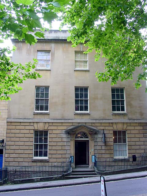
Georgian House Museum - This was originally home to John Pinney, a West India merchant, and the museum is set up to look as it was in his day. One display in the house explains how proceeds from commerial trading and the transatlantic slave trade have shaped Bristol as it is today.
Date
Source From geograph.org.uk
Author Linda Bailey
Permission
(Reusing this file)
Creative Commons Attribution Share-alike license 2.0
Camera location51° 27′ 14.31″ N, 2° 36′ 12.74″ W  Heading=135° Kartographer map based on OpenStreetMap.View this and other nearby images on: OpenStreetMapinfo


w:en:Creative Commons
attribution share alike
This file is licensed under the Creative Commons Attribution-Share Alike 2.0 Generic license.
Attribution: Linda Bailey
You are free:
  • to share – to copy, distribute and transmit the work
  • to remix – to adapt the work
Under the following conditions:
  • attribution – You must give appropriate credit, provide a link to the license, and indicate if changes were made. You may do so in any reasonable manner, but not in any way that suggests the licensor endorses you or your use.
  • share alike – If you remix, transform, or build upon the material, you must distribute your contributions under the same or compatible license as the original.

Captions

Add a one-line explanation of what this file represents
The Georgian House<\/a>"}},"text\/plain":{"en":{"P180":"The Georgian House"}}}}" class="wbmi-entityview-statementsGroup wbmi-entityview-statementsGroup-P180 oo-ui-layout oo-ui-panelLayout oo-ui-panelLayout-framed">

Items portrayed in this file

depicts

copyrighted<\/a>"}},"text\/plain":{"en":{"P6216":"copyrighted"}}}}" class="wbmi-entityview-statementsGroup wbmi-entityview-statementsGroup-P6216 oo-ui-layout oo-ui-panelLayout oo-ui-panelLayout-framed">
Creative Commons Attribution-ShareAlike 2.0 Generic<\/a>"}},"text\/plain":{"en":{"P275":"Creative Commons Attribution-ShareAlike 2.0 Generic"}}}}" class="wbmi-entityview-statementsGroup wbmi-entityview-statementsGroup-P275 oo-ui-layout oo-ui-panelLayout oo-ui-panelLayout-framed">

12 July 2006

file available on the internet<\/a>"}},"text\/plain":{"en":{"P7482":"file available on the internet"}}},"{\"value\":{\"entity-type\":\"property\",\"numeric-id\":137,\"id\":\"P137\"},\"type\":\"wikibase-entityid\"}":{"text\/html":{"en":{"":"operator<\/a>"}},"text\/plain":{"en":{"":"operator"}}},"{\"value\":{\"entity-type\":\"item\",\"numeric-id\":1503119,\"id\":\"Q1503119\"},\"type\":\"wikibase-entityid\"}":{"text\/html":{"en":{"P137":"Geograph Britain and Ireland<\/a>"}},"text\/plain":{"en":{"P137":"Geograph Britain and Ireland"}}},"{\"value\":{\"entity-type\":\"property\",\"numeric-id\":7384,\"id\":\"P7384\"},\"type\":\"wikibase-entityid\"}":{"text\/html":{"en":{"":"geograph.org.uk image ID<\/a>"}},"text\/plain":{"en":{"":"geograph.org.uk image ID"}}},"{\"value\":\"202215\",\"type\":\"string\"}":{"text\/html":{"en":{"P7384":"202215<\/a>"}},"text\/plain":{"en":{"P7384":"202215"}}},"{\"value\":{\"entity-type\":\"property\",\"numeric-id\":973,\"id\":\"P973\"},\"type\":\"wikibase-entityid\"}":{"text\/html":{"en":{"":"described at URL<\/a>"}},"text\/plain":{"en":{"":"described at URL"}}},"{\"value\":\"https:\\\/\\\/www.geograph.org.uk\\\/photo\\\/202215\",\"type\":\"string\"}":{"text\/html":{"en":{"P973":"https:\/\/www.geograph.org.uk\/photo\/202215<\/a>"}},"text\/plain":{"en":{"P973":"https:\/\/www.geograph.org.uk\/photo\/202215"}}}}" class="wbmi-entityview-statementsGroup wbmi-entityview-statementsGroup-P7482 oo-ui-layout oo-ui-panelLayout oo-ui-panelLayout-framed">
heading<\/a>"}},"text\/plain":{"en":{"":"heading"}}},"{\"value\":{\"amount\":\"+135\",\"unit\":\"http:\\\/\\\/www.wikidata.org\\\/entity\\\/Q28390\"},\"type\":\"quantity\"}":{"text\/html":{"en":{"P7787":"135 degree<\/span>"}},"text\/plain":{"en":{"P7787":"135 degree"}}}}" class="wbmi-entityview-statementsGroup wbmi-entityview-statementsGroup-P1259 oo-ui-layout oo-ui-panelLayout oo-ui-panelLayout-framed">

51°27'14.310"N, 2°36'12.744"W

heading: 135 degree
City of Bristol<\/a>"}},"text\/plain":{"en":{"P1071":"City of Bristol"}}}}" class="wbmi-entityview-statementsGroup wbmi-entityview-statementsGroup-P1071 oo-ui-layout oo-ui-panelLayout oo-ui-panelLayout-framed">

image/jpeg

84,908 byte

640 pixel

480 pixel

determination method or standard<\/a>"}},"text\/plain":{"en":{"":"determination method or standard"}}},"{\"value\":{\"entity-type\":\"item\",\"numeric-id\":13414952,\"id\":\"Q13414952\"},\"type\":\"wikibase-entityid\"}":{"text\/html":{"en":{"P459":"SHA-1<\/a>"}},"text\/plain":{"en":{"P459":"SHA-1"}}}}" class="wbmi-entityview-statementsGroup wbmi-entityview-statementsGroup-P4092 oo-ui-layout oo-ui-panelLayout oo-ui-panelLayout-framed">

dae6baf83ef2655b6e594928c715d5063598c5e1

File history

Click on a date/time to view the file as it appeared at that time.

Date/TimeThumbnailDimensionsUserComment
current14:05, 10 August 2021Thumbnail for version as of 14:05, 10 August 2021480 × 640 (83 KB)Bjh21Higher-resolution version from Geograph
16:39, 22 March 2008Thumbnail for version as of 16:39, 22 March 2008450 × 600 (69 KB)Imperialista~commonswiki== Summary == Georgian House Museum This was originally home to John Pinney, a West India merchant, and the museum is set up to look as it was in his day. One display in the house explains how proceeds from commerial trading and the transatlantic slave tr

Global file usage

The following other wikis use this file: