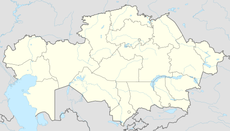
Shalkar
Shalkar
Шалқар | |
|---|---|
Town | |
 Mamedova Street | |
| Coordinates: 47°50′N 59°36′E / 47.833°N 59.600°E | |
| Country | Kazakhstan |
| Region | Aktobe Region |
| District | Shalkar District |
| Settlement | 1870 |
| Area | |
| • Total | 5 sq mi (12 km2) |
| Population (2009)[1] | |
| • Total | 26,574 |
| Time zone | UTC+5 (Yekaterinburg Time) |
Shalkar (Kazakh: , Şalqar) is a town and the administrative center of Shalkar District in Aktobe Region of western Kazakhstan.[2] Population: 26,574 (2009 Census results);[1] 26,329 (1999 Census results).[1]
Geography
[edit]The town is located in the southeastern sector of the Aktobe Region near the northern end of the Greater Barsuki Desert, close to Lake Shalkar.[3]
Climate
[edit]Shalkar has a semi-arid climate (Köppen: BSk)[4] with very cold winters and hot summers.
| Climate data for Shalkar (1991–2020) | |||||||||||||
|---|---|---|---|---|---|---|---|---|---|---|---|---|---|
| Month | Jan | Feb | Mar | Apr | May | Jun | Jul | Aug | Sep | Oct | Nov | Dec | Year |
| Mean daily maximum °C (°F) | −8.2 (17.2) |
−6.9 (19.6) |
2.4 (36.3) |
16.7 (62.1) |
25.2 (77.4) |
31.5 (88.7) |
33.3 (91.9) |
31.8 (89.2) |
24.4 (75.9) |
15.1 (59.2) |
2.6 (36.7) |
−5.4 (22.3) |
13.5 (56.3) |
| Daily mean °C (°F) | −12.7 (9.1) |
−12.2 (10.0) |
−3.3 (26.1) |
9.6 (49.3) |
17.5 (63.5) |
23.7 (74.7) |
25.6 (78.1) |
23.6 (74.5) |
16.0 (60.8) |
7.3 (45.1) |
−2.4 (27.7) |
−9.7 (14.5) |
6.9 (44.4) |
| Mean daily minimum °C (°F) | −16.8 (1.8) |
−16.7 (1.9) |
−7.6 (18.3) |
3.6 (38.5) |
10.0 (50.0) |
15.4 (59.7) |
17.6 (63.7) |
15.5 (59.9) |
8.5 (47.3) |
1.2 (34.2) |
−6.2 (20.8) |
−13.6 (7.5) |
0.9 (33.6) |
| Average precipitation mm (inches) | 12.0 (0.47) |
10.3 (0.41) |
18.4 (0.72) |
20.1 (0.79) |
22.5 (0.89) |
17.4 (0.69) |
15.0 (0.59) |
8.1 (0.32) |
5.9 (0.23) |
16.8 (0.66) |
16.6 (0.65) |
15.0 (0.59) |
178.1 (7.01) |
| Average precipitation days (≥ 1.0 mm) | 3.6 | 3.2 | 4.3 | 3.9 | 4.1 | 3.3 | 3.4 | 1.6 | 1.5 | 3.2 | 3.8 | 4.2 | 40.1 |
| Source: NOAA[5] | |||||||||||||
History
[edit]Shalkar (Chelkar) was founded in 1870 as a settlement. At the time, Chelkar was a part of Irgizsky Uyezd of Turgay Oblast and was connected to Yrgyz by a road. In the 1900s, the railroad connecting Orenburg and Tashkent was built. Chelkar became an important railway station. Between 1905 and 1907 the station building, the locomotive depot, as well as other facilities including a school and a hospital, were built. In 1918, Chelkar was an area of battles during the Russian Civil War.[6]
In 1920, Turgay Oblast was transformed to Turgay Governorate, and in 1921, it was abolished and included into Orenburg-Turgay Governorate. On May 26, 1921 Irgizsky District, a successor of Irgizsky Uyezd, was transferred to Aktyubinsk Governorate of Kirghiz Autonomous Soviet Socialist Republic. On July 5, 1922 the district was abolished, and Shalkar became the administrative center of Chelkarsky Uyezd. In 1925, the republic was renamed Kazak Autonomous Socialist Soviet Republic. On January 17, 1928 the governorate was abolished, and Chelkar was transferred to Aktyubinsk Okrug. The uyezds were abolished as well, and Chelkarsky Raion (District) was established.[7]
In 1928, Shalkar was granted a town status. On December 17, 1930 the okrug was abolished, and the districts became directly subordinate to the republic. In 1932, Aktobe Region was established, and in 1936, the republic was transformed into Kazakh Soviet Socialist Republic. In the 1930s Shalkar became a place for political exile, in particular, from Saint Petersburg.[6]
Economy
[edit]Industry
[edit]Shalkar is mostly serving the railway; there is a carriage repair plant. There are also food industry enterprises.[8]
Transportation
[edit]Shalkar is a railway station on the Trans-Aral Railway, which connects Orenburg and Tashkent. A branch line connects to Beyneu, from where trains can continue to various destinations, including the Caspian Sea port of Aktau. It is also connected to Irgiz by a road. This connection provides an access to the E38 highway between Aktobe and Shymkent.
Sport
[edit]A team was sent to the 2014 Youth Bandy Championship of Kazakhstan and also to the first round of the National Rink Bandy Championships in 2015 for players born in 1999-2000, held in Oral.[9]
References
[edit]- ^ a b c "Население Республики Казахстан" [Population of the Republic of Kazakhstan] (in Russian). Департамент социальной и демографической статистики. Retrieved 8 December 2013.
- ^ Шалкарский район (in Russian). Департамент статистики Актюбинской области. Retrieved 1 June 2012.
- ^ Google Earth.
- ^ "Table 1 Overview of the Köppen-Geiger climate classes including the defining criteria". Nature: Scientific Data.
- ^ "World Meteorological Organization Climate Normals for 1991-2020 — Shalkar". National Oceanic and Atmospheric Administration. Retrieved January 18, 2024.
- ^ a b Железняк, Сергей (June 28, 2007). С визитом к царю из Шалкарской пустыни (in Russian). Диапазон. Retrieved 1 June 2012.
- ^ Каратаев, Абат (February 2, 2012). От волостей к районам (in Russian). Актюбинский вестник. Retrieved 1 June 2012.
- ^ "L-40-VI. Челкар" (in Russian). narod.ru. Retrieved 1 June 2012.
- ^ "Спасибо, Андрей Евгеньевич! Вы - победитель!" (in Russian). Хоккейный клуб «Акжайык». Retrieved 4 August 2015.

