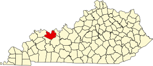
Moseleyville, Kentucky
Appearance
Moseleyville | |
|---|---|
| Country | United States |
| State | Kentucky |
| County | Daviess |
| Area | |
• Total | 1.07 sq mi (2.77 km2) |
| • Land | 1.04 sq mi (2.69 km2) |
| • Water | 0.03 sq mi (0.08 km2) |
| Population (2020) | |
• Total | 470 |
| • Density | 451.92/sq mi (174.47/km2) |
| Time zone | UTC-6 (Central (CST)) |
| • Summer (DST) | UTC-5 (CST) |
| ZIP code | 42301[2] |
| Area code(s) | 270 and 364 |
| FIPS code | 21-53670 |
Moseleyville is an census-designated place and unincorporated community located in Daviess County, Kentucky, United States.[3] The population was 470 as of the 2020 census.
Demographics
[edit]| Census | Pop. | Note | %± |
|---|---|---|---|
| 2020 | 470 | — | |
| U.S. Decennial Census[4] | |||
History
[edit]It was named for the Moseley family. There was a post office from 1886 to 1909.[5]
References
[edit]- ^ "2020 U.S. Gazetteer Files". United States Census Bureau. Retrieved March 18, 2022.
- ^ "Moseleyville KY ZIP Code". zipdatamaps.com. 2023. Retrieved June 16, 2023.
- ^ "Moseleyville Populated Place Profile / Daviess County, Kentucky Data". Kentucky.hometownlocator.com. July 1, 2016. Retrieved April 19, 2017.
- ^ "Census of Population and Housing". Census.gov. Retrieved June 4, 2016.
- ^ Rennick, Robert M. (1984). Kentucky Place Names. University Press of Kentucky. p. 204. ISBN 0813126312. Retrieved April 19, 2017.
37°39′47″N 87°11′36″W / 37.66306°N 87.19333°W
