Fort Albany (Arlington, Virginia)
| Fort Albany | |
|---|---|
| Arlington, Virginia | |
| Coordinates | 38°51′57″N 77°04′00″W / 38.86583°N 77.06667°W |
| Site history | |
| Built | 1861 |


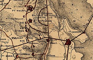
Fort Albany was a bastioned earthwork that the Union Army built in Arlington County (known at the time as Alexandria County) in Virginia. The Army constructed the fort during May 1861 as part of its Civil War defenses of Washington (see Washington, D.C., in the American Civil War).[1]
The fort was built by New York troops, and therefore named after the state capital of New York.[2] It had a perimeter of 429 yards and emplacements for 12 guns.[1] Fort Richardson, Fort Craig and Fort Tillinghast provided supporting fire for the fort.[1]
A May 17, 1864, report from the Union Army's Inspector of Artillery (see Union Army artillery organization) noted the following:
Fort Albany, Captain Rhodes commanding.–Garrison, one company First Massachusetts Volunteers–5 commissioned officers, 1 ordnance-sergeant, 145 men. Armament, two 24-pounder field howitzers, four 24-pounder siege, two Parrotts, one Coehorn mortar, one 10-inch mortar. Magazines, two; dry and in good order. Ammunition, full supply and in good condition. Implements, complete and in good order. Drill in artillery, fair. Drill in infantry, fair. Discipline, fair. Garrison of sufficient strength.[3] (See: Official Records of the War of the Rebellion)
The fort was abandoned in 1865, after the war ended.[2] No trace of it remains, although a historic marker shows the location where the fort once stood, guarding the approach to the Long Bridge along the Columbia Turnpike, near the modern-day Pentagon.[4] The ground on which the fort stood was cut away during the construction of the Henry G. Shirley Memorial Highway, in 1942.[1]
References
[edit]Citations
[edit]- ^ a b c d Cooling & Owen (2010), pp. 90–92.
- ^ a b "Fort Albany". Arlington Historical Society. Retrieved October 31, 2024.
- ^ Howe (1864), p. 888.
- ^ HMDB, Fort Albany (2008).
Sources
[edit]- Cooling, Benjamin Franklin, III; Owen, Walton H., II (2010). "Defense Posts for the Long Bridge — Forts Albany, Runyan, and Jackson: Fort Albany". Mr. Lincoln's Forts: A Guide to the Civil War Defenses of Washington (New ed.). Scarecrow Press. pp. 90–92. ISBN 978-0-8108-6307-1. LCCN 2009018392. OCLC 665840182. Archived from the original on 2018-03-12. Retrieved 2018-03-05 – via Google Books.
{{cite book}}: CS1 maint: multiple names: authors list (link) - Howe, A.P. (1864-05-17). "Report on the inspection of the defenses of Washington, made by the order of the Secretary of War: Fort Albany, Captain Rhodes commanding.". In Scott, Robert N. (ed.). The War of the Rebellion: A Compilation of the Official Records of the Union and Confederate Armies. Published under the direction of the Secretary of War (1880-1891). Series 1 (Military Operations), Volume 36, Part 2, Chapter 48 (Operations in Southeastern Virginia and North Carolina). Washington, DC: United States Government Printing Office. p. 888. LCCN 03003452. OCLC 224137463. Retrieved 2018-03-15 – via HathiTrust Digital Library.
- Swain, Craig, ed. (2008-02-09). ""Fort Albany" marker". HMdb.org: The Historical Marker Database. Archived from the original on 2018-03-08. Retrieved 2018-03-05.
External links
[edit]Drawing of Fort Albany in the collection of the Library of Congress Retrieved 2018-03-14.
- 1861 establishments in Virginia
- 1865 disestablishments in Virginia
- American Civil War forts in Virginia
- Buildings and structures in Arlington County, Virginia
- Civil War defenses of Washington, D.C.
- Military installations established in 1861
- Military installations closed in 1865
- Virginia in the American Civil War
