File:Deutsches Reich (1871-1918)-ar.svg
Jump to navigation
Jump to search

Size of this PNG preview of this SVG file: 595 × 599 pixels. Other resolutions: 238 × 240 pixels | 477 × 480 pixels | 762 × 768 pixels | 1,017 × 1,024 pixels | 2,033 × 2,048 pixels | 830 × 836 pixels.
Original file (SVG file, nominally 830 × 836 pixels, file size: 624 KB)
Captions
Captions
Sanjay kumar
Summary
[edit]| Description |
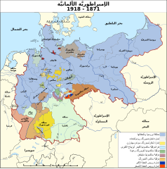
العربية: خريطة الإمبراطوريَّة الألمانيَّة 1871-1918 |
| Date | |
| Source | Derivative from: this file |
| Author | |
| Other versions |
[]
|


Licensing
[edit]I, the copyright holder of this work, hereby publish it under the following licenses:

|
Permission is granted to copy, distribute and/or modify this document under the terms of the GNU Free Documentation License, Version 1.2 or any later version published by the Free Software Foundation; with no Invariant Sections, no Front-Cover Texts, and no Back-Cover Texts. A copy of the license is included in the section entitled GNU Free Documentation License. |
This file is licensed under the Creative Commons Attribution-Share Alike 4.0 International, 3.0 Unported, 2.5 Generic, 2.0 Generic and 1.0 Generic license.
- You are free:
- to share – to copy, distribute and transmit the work
- to remix – to adapt the work
- Under the following conditions:
- attribution – You must give appropriate credit, provide a link to the license, and indicate if changes were made. You may do so in any reasonable manner, but not in any way that suggests the licensor endorses you or your use.
- share alike – If you remix, transform, or build upon the material, you must distribute your contributions under the same or compatible license as the original.
You may select the license of your choice.
File history
Click on a date/time to view the file as it appeared at that time.
| Date/Time | Thumbnail | Dimensions | User | Comment | |
|---|---|---|---|---|---|
| current | 19:05, 12 February 2017 | 830 × 836 (624 KB) | باسم (talk | contribs) | User created page with UploadWizard |
You cannot overwrite this file.
File usage on Commons
The following 13 pages use this file:
- File:Deutsches Reich (1871-1918)-ar.svg
- File:Deutsches Reich (1871-1918)-de.svg
- File:Deutsches Reich (1871-1918)-en.png
- File:Deutsches Reich (1871-1918)-eo.svg
- File:Deutsches Reich (1871-1918)-es.svg
- File:Deutsches Reich (1871-1918)-fa.svg
- File:Deutsches Reich (1871-1918)-fr.svg
- File:Deutsches Reich (1871-1918)-he.svg
- File:Deutsches Reich (1871-1918)-ms.svg
- File:Deutsches Reich (1871-1918)-oc.png
- File:Deutsches Reich (1871-1918)-tr.svg
- File:German Empire states map-ms.svg
- Template:Other versions/Map German Empire (1871-1918)
File usage on other wikis
The following other wikis use this file:
- Usage on ar.wikipedia.org
- ألمانيا
- معاهدة فرساي
- ولاية بريمن
- بروسيا
- القيصرية الألمانية
- مستخدم:Thabet202/تجارب/المانيا/تاريخ
- الرايخ الألماني
- مملكة بروسيا
- مملكة بافاريا
- قالب:ولايات الإمبراطورية الألمانية
- مملكة ساكسونيا
- مملكة فورتمبيرغ
- توحيد ألمانيا (1871)
- دوقية بادن الكبرى
- دوقية أولدنبورغ الكبرى
- دوقية ساكسونيا فايمر أيزيناخ الكبرى
- دوقية مكلنبورغ ستريليتس الكبرى
- دوقية مكلنبورغ شفيرين الكبرى
- دوقية هسن الكبرى
- أنهالت
- الألزاس واللورين
- فالدك
- إمارة شفارتسبورغ سوندرسهاوزن
- إمارة شفارتسبورغ رودولشتات
- دوقية ساكسونيا مايننغن
- دوقية ساكسونيا كوبورغ وغوتا
- دوقية ساكسونيا ألتنبورغ
- إمارة رويس الخط الأكبر
- شاومبورغ ليبه
- ليبه (أرض)
- دوقية براونشفايغ
- دوقية ساكسونيا لاونبورغ
- بوابة:الإمبراطورية الألمانية
- بوابة:الإمبراطورية الألمانية/قوالب
- بوابة:الإمبراطورية الألمانية/صورة مختارة/6
- قالب:إطار2
- بوابة:الإمبراطورية الألمانية/صورة مختارة/أرشيف
- قالب:إطار2/شرح
- ويكيبيديا:ورشة الصور/أرشيف 26
- الإمبراطورية الألمانية الاستعمارية
- دول الإمبراطورية الألمانية
- مستخدم:Marksman003/قائمة بشعارات النبالة في ألمانيا
- قائمة الولايات التاريخية الألمانية
- ألمانيا الصغرى
- Usage on arz.wikipedia.org