Category:Staining, Lancashire
Jump to navigation
Jump to search
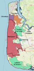
English: Staining is a village and civil parish in Lancashire, England, situated on a coastal plain called the Fylde. it is close to the seaside resorts of Blackpool and Lytham St Annes, as well as the market town of Poulton-le-Fylde. In the 2001 United Kingdom Census, the parish had a population of 2,312. Historically, the village was part of the township of Hardhorn-with-Newton. Now the hamlet of Newton is part of the civil parish of Staining; Hardhorn belongs to Poulton-le-Fylde. (→Staining, Lancashire)
Polski: Staining – wieś w Anglii, w hrabstwie Lancashire, w dystrykcie Fylde. Leży 64 km na północny zachód od miasta Manchester i 322 km na północny zachód od Londynu. (→Staining (Lancashire))
village and civil parish in Lancashire, England  | |||||
| Upload media | |||||
| Instance of | |||||
|---|---|---|---|---|---|
| Location | Fylde, Lancashire, North West England, England | ||||
| Population |
| ||||
 | |||||
Media in category "Staining, Lancashire"
The following 74 files are in this category, out of 74 total.
-
A Fore Gone Conclusion - geograph.org.uk - 1196954.jpg 640 × 426; 138 KB
-
A plough horse - geograph.org.uk - 5799121.jpg 4,515 × 2,742; 6.18 MB
-
A pond at the edge of Heron's Reach Golf Course - geograph.org.uk - 5799034.jpg 4,497 × 2,947; 7.83 MB
-
Approaching Staining - geograph.org.uk - 1394608.jpg 640 × 480; 178 KB
-
Bibby Drive, Staining - geograph.org.uk - 1394617.jpg 640 × 480; 137 KB
-
BlackpoolBUA.png 413 × 850; 422 KB
-
Broad Oak Lane, Staining - geograph.org.uk - 4228549.jpg 640 × 480; 121 KB
-
Chain Lane - geograph.org.uk - 4228547.jpg 640 × 480; 56 KB
-
Chain Lane, Staining - geograph.org.uk - 4228540.jpg 640 × 480; 76 KB
-
Chain Lane, Staining - geograph.org.uk - 6064297.jpg 1,600 × 1,065; 444 KB
-
Crossings Wood - geograph.org.uk - 5791059.jpg 4,592 × 3,056; 7.89 MB
-
Cycle path at Broad Oak Lane, Staining - geograph.org.uk - 6063692.jpg 1,600 × 1,065; 865 KB
-
Cycle track towards Staining - geograph.org.uk - 6063687.jpg 1,600 × 1,065; 691 KB
-
Dover Caravan Park - geograph.org.uk - 1394621.jpg 640 × 480; 125 KB
-
Electricity Pylon East of Staining - geograph.org.uk - 5946813.jpg 2,784 × 1,568; 2.06 MB
-
Entering Staining - geograph.org.uk - 4228533.jpg 640 × 480; 53 KB
-
Ex-WW2 Hangars near to Marton Mere - geograph.org.uk - 996462.jpg 640 × 427; 39 KB
-
Farm Road near Crossings Wood - geograph.org.uk - 2756979.jpg 4,000 × 3,000; 5.11 MB
-
Farm Road near Mereview - geograph.org.uk - 2757005.jpg 4,000 × 3,000; 4.98 MB
-
Farmland and hedgerow near Hawes House - geograph.org.uk - 3384950.jpg 800 × 574; 109 KB
-
Farmland, Todderstaffe Hall - geograph.org.uk - 3384952.jpg 800 × 567; 85 KB
-
Staining village flag.svg 1,033 × 620; 23 KB
-
Floral display in Staining - geograph.org.uk - 3731352.jpg 2,579 × 1,855; 765 KB
-
Flowerbed near Staining - geograph.org.uk - 1385063.jpg 640 × 480; 133 KB
-
Footpath leading to Todderstaffe Hall - geograph.org.uk - 6064304.jpg 1,600 × 1,065; 567 KB
-
Footpath Over Golf Course - geograph.org.uk - 1196961.jpg 640 × 426; 129 KB
-
-
Grazing east of Smithy Lane - geograph.org.uk - 4228521.jpg 640 × 480; 50 KB
-
Grazing near Staining - geograph.org.uk - 4228529.jpg 640 × 480; 49 KB
-
Grazing, Normoss - geograph.org.uk - 4228550.jpg 640 × 480; 61 KB
-
Grazing, Staining - geograph.org.uk - 4228536.jpg 640 × 480; 54 KB
-
Grazing, Staining - geograph.org.uk - 4228548.jpg 640 × 480; 51 KB
-
Hawes House - geograph.org.uk - 2361649.jpg 1,024 × 768; 183 KB
-
Leaving Staining on Chain Lane - geograph.org.uk - 1394619.jpg 640 × 480; 123 KB
-
Level Crossing and Train by Crossings Wood - geograph.org.uk - 2756983.jpg 4,000 × 3,000; 4.94 MB
-
Maclaren Close, Staining - geograph.org.uk - 1394610.jpg 640 × 480; 133 KB
-
Main Dyke near Crossings Wood - geograph.org.uk - 2756974.jpg 1,200 × 1,600; 680 KB
-
Meadow Park, Staining - geograph.org.uk - 1394612.jpg 640 × 480; 135 KB
-
Mill Lane, Staining - geograph.org.uk - 3731348.jpg 4,067 × 2,652; 1.25 MB
-
Mill Lane, Staining - geograph.org.uk - 4228537.jpg 640 × 480; 65 KB
-
Mini-roundabout in Staining - geograph.org.uk - 1394614.jpg 640 × 480; 133 KB
-
Mushroom Farm - geograph.org.uk - 1196991.jpg 640 × 426; 114 KB
-
Pipe Bridge crossing Main Dyke from Chain Lane - geograph.org.uk - 2756922.jpg 3,000 × 4,000; 3.92 MB
-
Pond near Todderstaffe Hall - geograph.org.uk - 2361645.jpg 3,072 × 2,304; 1.48 MB
-
Pond on the golf course - geograph.org.uk - 2757056.jpg 1,200 × 1,600; 379 KB
-
Preese Hall Footbridge - geograph.org.uk - 5946842.jpg 2,784 × 1,568; 2.06 MB
-
Pylon lines cross Chain Lane - geograph.org.uk - 1394623.jpg 640 × 480; 117 KB
-
Rail line at Crossings Wood - geograph.org.uk - 6064322.jpg 1,600 × 1,065; 511 KB
-
Road to Staining Lodge Golf Course - geograph.org.uk - 1394620.jpg 640 × 480; 154 KB
-
Sign for the Plough, Staining - geograph.org.uk - 4228539.jpg 648 × 728; 191 KB
-
Smithy Lane - geograph.org.uk - 2361712.jpg 1,024 × 732; 102 KB
-
Smithy Lane - geograph.org.uk - 4228524.jpg 640 × 480; 68 KB
-
Smithy Lane - geograph.org.uk - 4228532.jpg 640 × 480; 49 KB
-
Sports field, Staining - geograph.org.uk - 4228545.jpg 640 × 480; 44 KB
-
Staining Centre - geograph.org.uk - 106854.jpg 640 × 426; 142 KB
-
Staining Hall Farm - geograph.org.uk - 5946825.jpg 2,784 × 1,568; 2.17 MB
-
Staining Lodge golf course - geograph.org.uk - 5780711.jpg 4,592 × 2,816; 7.92 MB
-
Staining Lodge golf course - geograph.org.uk - 5780737.jpg 3,955 × 2,631; 6.29 MB
-
Staining Road - geograph.org.uk - 4228552.jpg 640 × 480; 67 KB
-
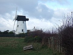
Staining Windmill - geograph.org.uk - 4228535.jpg 480 × 640; 51 KB
-
Staining Windmill - geograph.org.uk - 653874.jpg 640 × 480; 54 KB
-
Staining Windmill - geograph.org.uk - 653908.jpg 480 × 640; 52 KB
-
Staining Windmill from Smithy Lane - geograph.org.uk - 2361730.jpg 1,600 × 1,155; 259 KB
-
Staining, Lancashire - geograph.org.uk - 1385052.jpg 640 × 480; 115 KB
-
The Co-Operative, Staining - geograph.org.uk - 1385058.jpg 640 × 480; 134 KB
-
The path by Todderstaffe Farm - geograph.org.uk - 5791947.jpg 3,056 × 4,592; 6.16 MB
-
The Plough - geograph.org.uk - 5798940.jpg 4,325 × 2,842; 7.85 MB
-
The Plough at Staining - geograph.org.uk - 653933.jpg 640 × 480; 44 KB
-
The Plough, Staining - geograph.org.uk - 4228538.jpg 640 × 395; 44 KB
-
The stile by Todderstaffe Farm - geograph.org.uk - 5791824.jpg 4,334 × 2,591; 7.2 MB
-
The track to Staining Hall Farm - geograph.org.uk - 5798821.jpg 4,592 × 3,056; 6.75 MB
-
Todderstaffe Hall - geograph.org.uk - 6064319.jpg 1,600 × 1,065; 516 KB
-
Todderstaffe Hall Farm - geograph.org.uk - 1163772.jpg 640 × 479; 137 KB
-
Westfield Avenue, Normoss - geograph.org.uk - 1939082.jpg 640 × 480; 79 KB