Category:Neerpelt
Jump to navigation
Jump to search
Nederlands: Afbeeldingen van Neerpelt behorende tot de gemeente Pelt in de provincie Limburg (Belgische provincie) in het noordoosten van België
section of Pelt, Belgium | |||||
| Upload media | |||||
| Instance of |
| ||||
|---|---|---|---|---|---|
| Location | Pelt, Arrondissement of Maaseik, Limburg, Flemish Region, Belgium | ||||
| Located in or next to body of water | |||||
| Population |
| ||||
| Area |
| ||||
| official website | |||||
 | |||||
Subcategories
This category has the following 6 subcategories, out of 6 total.
Media in category "Neerpelt"
The following 16 files are in this category, out of 16 total.
-
Blason ville be Neerpelt.svg 600 × 660; 59 KB
-
C2 0142 neerpelt tassetstraat zicht 02 - 371390 - onroerenderfgoed.jpg 2,148 × 1,568; 3.18 MB
-
Dommelhof Neerpelt Pelt.jpg 5,472 × 3,648; 5.43 MB
-
Kanaal Bocholt-Herentals.jpg 2,288 × 1,712; 750 KB
-
Maria en kind, Teo Groenen - Neerpelt..jpg 1,800 × 3,692; 1.59 MB
-
Neerpelt coa.svg 289 × 326; 9 KB
-
Neerpelt Jaak Tassetstraat 33 - 171785 - onroerenderfgoed.jpg 438 × 640; 64 KB
-
Neerpelt Kerkstraat 26-28 - 171792 - onroerenderfgoed.jpg 640 × 428; 53 KB
-
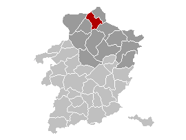
Neerpelt Limburg Belgium Map.png 270 × 203; 5 KB
-
Neerpelt Vlag - 25472 - onroerenderfgoed.jpg 1,500 × 1,000; 119 KB
-
Neerpelt vlag.svg 879 × 585; 7 KB
-
Neerpelt Wapen - 25473 - onroerenderfgoed.jpg 1,000 × 1,500; 135 KB
-
Neerpelt wapen.svg 670 × 780; 8 KB
-
Neerpelt.jpg 290 × 315; 13 KB
-
Sint-Hubertuscollege.jpg 450 × 303; 57 KB


