Category:Locator maps of Spain
Jump to navigation
Jump to search

The locator maps of provinces of Spain have been classified in different schemes following the colours or the format of the maps (SVG, PNG, etc.):
- Schemes for provinces and autonomous communities


- Schemes for provinces only


- Schemes for autonomous communities only


Subcategories
This category has the following 7 subcategories, out of 7 total.
!
*
1
2
Media in category "Locator maps of Spain"
The following 63 files are in this category, out of 63 total.
-
100 montaditos footprint in Spain and Andorra.png 1,184 × 1,016; 147 KB
-
Benacazongeografia.jpg 1,173 × 696; 119 KB
-
Biogeo España.jpg 392 × 320; 26 KB
-
Calellamap.jpg 377 × 385; 21 KB
-
CampiñaSegoviaMapa.png 2,444 × 2,050; 672 KB
-
Canary Islands, Spain (orthographic projection).png 549 × 548; 105 KB
-
Castilla en España.png 1,388 × 972; 568 KB
-
Coasts of Spain map.png 469 × 398; 13 KB
-
El Zabal.png 800 × 906; 242 KB
-
Enclaves of Spain.png 900 × 783; 234 KB
-
España interior.JPG 699 × 600; 31 KB
-
España txikipedia.png 1,200 × 685; 205 KB
-
EU location ESP.png 1,600 × 1,200; 475 KB
-
Europe location ESP.png 1,600 × 1,200; 712 KB
-
Europe map spain.png 1,231 × 929; 41 KB
-
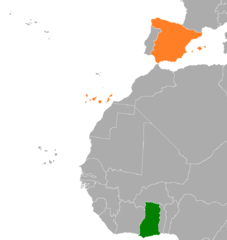
Ghana Spain Locator.png 1,036 × 1,096; 24 KB
-
Ispanya cb.png 340 × 231; 8 KB
-
Localizacionejulveteruel.png 314 × 202; 19 KB
-
Location Spain EU Europe (square).jpg 417 × 417; 37 KB
-
Location Spain EU Europe 5.png 2,056 × 1,727; 232 KB
-
Location Spain EU Europe 6.png 2,056 × 1,727; 243 KB
-
Location Spain EU.png 334 × 278; 20 KB
-
LocationSpain.png 250 × 115; 6 KB
-
LocationSpainInEurope.png 415 × 422; 10 KB
-
LocMap of WH BarMusCatHosPau.png 275 × 260; 52 KB
-
Los Lirios EL B.png 1,000 × 688; 146 KB
-
Los Lirios EL Bueno.png 1,000 × 688; 144 KB
-
Los Lirios Mapa.png 1,000 × 688; 145 KB
-
Map Spain Levante.png 467 × 394; 17 KB
-
Mapa Asociados ANF7 (Abril 2012).jpg 501 × 346; 45 KB
-
Mapa CEEM.png 3,333 × 2,791; 527 KB
-
Mapa con AO en España.png 1,705 × 1,185; 47 KB
-
Mapa El Castillar.jpg 1,753 × 998; 190 KB
-
Mapa-zonas.jpg 534 × 446; 124 KB
-
Mapaenclaves.jpg 1,705 × 1,185; 232 KB
-
MapaFolletoRecida2.jpg 400 × 340; 115 KB
-
MapRecida.jpg 300 × 255; 56 KB
-
Meridalocation.png 300 × 194; 13 KB
-
Noalejo municipality.png 1,454 × 1,063; 301 KB
-
Norte de España.JPG 699 × 600; 32 KB
-
-
Parasite180153-fig1 Thelazia callipaeda (Nematoda) map.png 637 × 633; 52 KB
-
Parques.jpg 300 × 226; 3 KB
-
Situación geográfica de Ad Ello (Elda).jpg 264 × 269; 20 KB
-
Spain (orthographic projection) de iure.png 553 × 553; 177 KB
-
Spain (orthographic projection).png 550 × 550; 130 KB
-
Spain Finland Locator.png 1,236 × 1,245; 79 KB
-
Spain in its region.png 2,068 × 1,314; 846 KB
-
Spain location map - Andalusia.png 699 × 600; 72 KB
-
Spain location map - Central Spain.png 699 × 600; 72 KB
-
Spain location map - Eastern Spain.png 699 × 600; 73 KB
-
Spain location map - Green Spain.png 699 × 600; 72 KB
-
Spain location map - Northern Spain.png 699 × 600; 72 KB
-
Spain Relief Map w Atapuerca.png 1,197 × 1,027; 1.87 MB
-
Spain, world location.png 799 × 370; 68 KB
-
Spain-Location-Map(2013)-UNOCHA-no-logo.png 500 × 500; 92 KB
-
Spainrachelrocket72.jpg 500 × 388; 54 KB
-
Spanias hjemmekamper.jpg 699 × 600; 69 KB
-
Spanish State.png 2,000 × 2,000; 498 KB
-
Sur de España.JPG 699 × 600; 31 KB
-
Ubicacion lfia.png 350 × 354; 65 KB
-
World Factbook (1982) Spain.jpg 585 × 586; 87 KB
-
Zona Sublevada octubre 1937.png 450 × 456; 51 KB