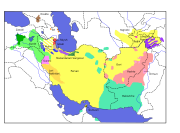
File:Iranian tongues.svg

Size of this PNG preview of this SVG file: 800 × 591 pixels. Other resolutions: 320 × 236 pixels | 640 × 473 pixels | 1,024 × 756 pixels | 1,280 × 945 pixels | 2,560 × 1,891 pixels | 838 × 619 pixels.
Original file (SVG file, nominally 838 × 619 pixels, file size: 154 KB)
File information
Structured data
Captions
Captions
Add a one-line explanation of what this file represents
References for this description (or part of this) or for the depiction in the file are not provided.
|
| DescriptionIranian tongues.svg |
English: Map of Iranian languages
Esperanto: Mapo de Iranaj lingvoj
Français : Carte des langues iraniennes |
|
| Date | ||
| Source | made using File:Iranische Sprachen.jpg as a source | |
| Author | Fabienkhan | |
| Permission (Reusing this file) |
This file is licensed under the Creative Commons Attribution-Share Alike 2.5 Generic license.
|
|
| Other versions |
Derivative works of this file: Iranian tongues es.svg
[edit]
|
|
| SVG development InfoField |
|
File history
Click on a date/time to view the file as it appeared at that time.
| Date/Time | Thumbnail | Dimensions | User | Comment | |
|---|---|---|---|---|---|
| current | 15:38, 3 June 2023 | 838 × 619 (154 KB) | Golden (talk | contribs) | There are no Persian speakers in south-west Republic of Azerbaijan (or anywhere in Rep. of Azerbaijan), no Tat speaker in Qusar and much smaller size in Ismayilli. Not everywhere in West Azerbaijan Province is kurdish speaking, extended the hashed lines | |
| 15:04, 22 May 2007 | 838 × 619 (178 KB) | Fabienkhan (talk | contribs) | fixed a legend | ||
| 14:55, 22 May 2007 | 838 × 619 (178 KB) | Fabienkhan (talk | contribs) | {{Information |Description=Map of Iranian languages |Source=made using Image:Iranische Sprachen.jpg as a source |Date=22/05/2007 |Author=Fabienkhan |Permission={{cc-by-sa-2.5}} |other_versions=original image in german : [[:Image:I |
You cannot overwrite this file.
File usage on Commons
The following 14 pages use this file:
- Atlas of Iraqi Kurdistan
- Atlas of Kurdistan
- Atlas of North Ossetia – Alania
- Atlas of South Ossetia
- Atlas of Western Kurdistan
- User:Chumwa/OgreBot/Travel and communication maps/2023 June 1-10
- File:Civilisations actuelles.png
- File:Iranian tongues-nl.svg
- File:Iranian tongues-tr.svg
- File:Iranian tongues.svg
- File:Iranian tongues de.svg
- File:Iranian tongues eo.svg
- File:Iranian tongues es.svg
- Template:Other versions/Iranian tongues
File usage on other wikis
The following other wikis use this file:
- Usage on af.wikipedia.org
- Usage on an.wikipedia.org
- Usage on be-tarask.wikipedia.org
- Usage on da.wikipedia.org
- Usage on en.wikipedia.org
- Usage on fr.wikipedia.org
- Usage on hr.wiktionary.org
- Usage on ko.wikipedia.org
- Usage on pt.wikipedia.org
- Usage on simple.wikipedia.org
- Usage on tr.wikipedia.org
Metadata
This file contains additional information such as Exif metadata which may have been added by the digital camera, scanner, or software program used to create or digitize it. If the file has been modified from its original state, some details such as the timestamp may not fully reflect those of the original file. The timestamp is only as accurate as the clock in the camera, and it may be completely wrong.
| Width | 670pt |
|---|---|
| Height | 495pt |


