South Holland
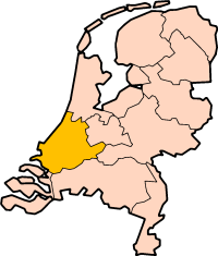
South Holland is a province in the west of the Netherlands. It is called Zuid-Holland in Dutch. It is surrounded by the North Sea and the provinces North Holland, Utrecht, Gelderland, North Brabant, and Zeeland. About 3,805,000 people are living in South Holland (2023).
South Holland
Zuid-Holland | |
|---|---|
Province | |
 | |
 Location | |
 Map | |
| Coordinates: 51°59′N 4°30′E / 51.983°N 4.500°E | |
| Country | Netherlands |
| Established | 1840 |
| Seat | The Hague (Den Haag) |
| Area | |
| • Total | 3,308 km2 (1,277 sq mi) |
| • Land | 2,698 km2 (1,042 sq mi) |
| • Water | 609 km2 (235 sq mi) |
| Highest elevation | 37 m (121 ft) |
| Lowest elevation | −7 m (−23 ft) |
| Population (2023) | |
| • Total | 3,805,000 |
| • Density | 1,410/km2 (3,700/sq mi) |
| Website | www |
Cities
changeThe biggest cities are Rotterdam and The Hague. The Hague is the capital of the province. The Hague is also the administrative capital of the Netherlands. That means that the parliament is there.
Rotterdam has the largest port of Europe. Leiden, Gouda, and Delft have town centers with many old buildings. Zoetermeer is a quite new city. Most of it was built in the 1970s. Another important city is Dordrecht.
Landscapes
changeIn South Holland there are some typical Dutch landscapes. Near Leiden there is a region that is known as the Bollenstreek ("bulb district"). In springtime many large fields with flowers can be found here. These fields are called bulb fields. Near Rotterdam there is a small village called Kinderdijk with 19 windmills near each other.
The area south of The Hague is called Westland. Here are many greenhouses.
Islands
changeThe south of the province has many islands. The largest of them are Voorne-Putten, Goeree-Overflakkee, IJsselmonde, the Hoeksche Waard and the island of Dordrecht. These big islands are connected by bridges and/or tunnels.
Water resources
changeThe most important rivers and other bodies of waters are Nieuwe Maas, Nieuwe Waterweg, Oude Maas, Haringvliet, and Hollands Diep.

