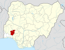
Ola Oluwa
Appearance
Ola Oluwa | |
|---|---|
| Coordinates: 7°47′N 4°13′E / 7.783°N 4.217°E | |
| Country | Nigeria |
| State | Osun State |
| Government | |
| • Local Government Chairman | Asimiyu Amobi Oyediran |
| Area | |
• Total | 328 km2 (127 sq mi) |
| Population (2006 Census) | |
• Total | 76,593 |
| Time zone | UTC+1 (WAT) |
| 3-digit postal code prefix | 232 |
| ISO 3166 code | NG.OS.OL |
 | |
Ola Oluwa is a Local Government Area in Osun State, Nigeria. Its headquarters are in the town of Bode Osi. It was formally called Iwo North Local Government on establishment, which was formally changed after the death of ọba abímbólá, the then Oluwo of Iwo. It's now as another Local Government making two which is Ola Oluwa South East LCD[1] A, Ilemowu.
It has an area of 328 km2 and a population of 76,593 according to the 2006 census.
Tertiary Education
The Local Government has two functioning private institution and one under construction, which are
- Westland university,[2] in iwara
- Wolex polytechnic,[3] iwara;
- Mercy Medical University,[4] Ìkirè ilé
- Iwo College of Health Science and Technology, Amere.
The postal code of the area is 232.[5]
References
- ^ "LG'S , LCDA'S AND AREA COUNCILS | State of Osun Official Website". Retrieved 2020-11-23.
- ^ "Westland University, Iwo – Technology is Power". Retrieved 2020-11-23.
- ^ "Wolex Polytechnic". Wolex Polytechnic. Retrieved 2020-11-23.
- ^ DitoMasso - (2020-07-17). "Oluwo, Akire Lay Private University Foundation". LATEST NEWS. Retrieved 2020-11-23.
- ^ "Post Offices- with map of LGA". NIPOST. Archived from the original on 2012-11-26. Retrieved 2009-10-20.

