Old maps: Difference between revisions
Jump to navigation
Jump to search
Content deleted Content added
→North America: Rail Tags: Mobile edit Mobile web edit |
link to Atlas of the Middle Ages (not only old maps) |
||
| (30 intermediate revisions by 8 users not shown) | |||
| Line 1: | Line 1: | ||
{{TOCleft}}{{Old maps meaning|Maps|inhibit=1}} |
{{TOCleft}}{{Old maps meaning|Maps|inhibit=1}} |
||
Old |
Old [[map]]s are included in the [[Image:Wikimedia-logo.svg|15px]]''' Wikimedia [[Atlas]] <!-- dead link:[[:Category:Atlas_entries_with_old_maps|Atlas]] -->''' [[Image:Gnome-globe.svg|15px]]. |
||
| ⚫ | |||
| ⚫ | |||
{{for2|maps showing regional history|[[Atlas of regional history]]}} |
|||
| ⚫ | |||
| ⚫ | |||
== World maps == |
== World maps == |
||
<gallery> |
<gallery> |
||
| Line 11: | Line 13: | ||
Image:Ct000725C-wh012_5-Universalis_cosmographia_secundum_Ptholomaei_traditionem_et_Americi_Vespucii_alioru-m-que_lustrationes..png|[[Waldseemüller_map|World map of Waldseemüller]], which first used the name America, 1507 |
Image:Ct000725C-wh012_5-Universalis_cosmographia_secundum_Ptholomaei_traditionem_et_Americi_Vespucii_alioru-m-que_lustrationes..png|[[Waldseemüller_map|World map of Waldseemüller]], which first used the name America, 1507 |
||
Image:Ebstorfer-stich2.jpg|''Ebstorfer'' world map |
Image:Ebstorfer-stich2.jpg|''Ebstorfer'' world map |
||
Image:Radkarte MKL1888.png|World map from the Middle Ages |
Image:Radkarte MKL1888.png|World map from the [[Atlas of the Middle Ages|Middle Ages]] |
||
Image:Part of Tabula Peutingeriana.jpg|Part of Tabula Peutingeriana |
Image:Part of Tabula Peutingeriana.jpg|Part of [[Tabula Peutingeriana]] |
||
Image:Schedel weltkarte.jpg|from [[Hartmann Schedels Weltchronik|Hartmann Schedels Worldchronic]] (1493) |
Image:Schedel weltkarte.jpg|from [[Hartmann Schedels Weltchronik|Hartmann Schedels Worldchronic]] (1493) |
||
Image:Kepler-world.jpg|World map by Johannes Kepler |
Image:Kepler-world.jpg|World map by Johannes Kepler |
||
Image:Hereford Mappa Mundi 1300.jpg|[[Hereford Mappa Mundi, c.1300]] |
Image:Hereford Mappa Mundi 1300.jpg|[[Hereford Mappa Mundi, c.1300]] |
||
Image:Al-Idrisi's world map.JPG|Al-Idrisi's world map |
Image:Al-Idrisi's world map.JPG|Al-Idrisi's world map |
||
File:Ca._1503_world_map_by_Gregor_Reisch.jpg|1503 |
|||
File:Globe_vert_America.tif|1700 |
|||
Image:Fries_worldmap_1522.jpg|Laurent Fries world map, 1522 |
Image:Fries_worldmap_1522.jpg|Laurent Fries world map, 1522 |
||
Image:Mundo_Novo.JPG|Pedro de Medina & G.B. Pedrazano, 1554 |
Image:Mundo_Novo.JPG|Pedro de Medina & G.B. Pedrazano, 1554 |
||
| Line 27: | Line 31: | ||
Image:Magna Carta Mundi 1670 (Nicolaus Ioannis Vischerius).jpg|Magna Carta Mundi (1670) |
Image:Magna Carta Mundi 1670 (Nicolaus Ioannis Vischerius).jpg|Magna Carta Mundi (1670) |
||
Image:Capt Dampier's new voyage to New Holland &c in 1699 - Project Gutenberg eText 15675.jpg|Capt Dampier's new voyage to New Holland (1699) |
Image:Capt Dampier's new voyage to New Holland &c in 1699 - Project Gutenberg eText 15675.jpg|Capt Dampier's new voyage to New Holland (1699) |
||
File:Wang_Jun_Fu_World_Map.jpg|Wang Jun Fu World Map (1680) |
|||
File:Ca._1690_world_map_-_Orbis_Terrarum_Nova_et_Accurata_Tabula.jpg|1690 |
|||
File:17th_century_world_map_-_Nova_Totius_Terrarum_Orbis_Tabula.jpg |
|||
Image:Fernando de Noronha map by Philippe Buache 1737.jpg|by Philippe Buache (1737) |
Image:Fernando de Noronha map by Philippe Buache 1737.jpg|by Philippe Buache (1737) |
||
Image:Map-031.jpg|by Pîrî Reîs |
Image:Map-031.jpg|by Pîrî Reîs |
||
File:Ca._1750_Japanes_world_map_-_Chiku_Bankoku_Ichizan_no_Zu_-_Comprehensive_Image_of_the_World%27s_Myriad_Countries.jpg|1750 Japanese map |
|||
Image:Piri reis world map 01.jpg|by Pîrî Reîs |
Image:Piri reis world map 01.jpg|by Pîrî Reîs |
||
Image:Datumsgrenze MK1888.png|Historical map of the international dateline |
Image:Datumsgrenze MK1888.png|Historical map of the international dateline |
||
Image:Leonhard_Euler_World_Map_AD1760.jpg|Antique World Map with magnetic declination by Leonhard Euler (1753) |
Image:Leonhard_Euler_World_Map_AD1760.jpg|Antique World Map with magnetic declination by Leonhard Euler (1753) |
||
Image:Alexander den stores rike, Nordisk familjebok.jpg|(1902-1924) |
Image:Alexander den stores rike, Nordisk familjebok.jpg|(1902-1924) |
||
File:Eastern_Mediterranean_-_1924_Ogawa_Jihei_and_Maekawa_Senpan_Cartoon_Map_of_the_World_(cropped).jpg|1924 |
|||
Image:Pieni 1 0017.jpg|Map of Asia with Finnish text from "Pieni Tietosanakirja" (1925) |
Image:Pieni 1 0017.jpg|Map of Asia with Finnish text from "Pieni Tietosanakirja" (1925) |
||
File:1932_Japanese_pictorial_world_map_game_board.jpg|1932 artwork |
|||
</gallery> |
</gallery> |
||
===See also=== |
===See also=== |
||
| Line 68: | Line 79: | ||
Image:Oregontrail_1907.jpg|[[Oregon]] Trail (1907) |
Image:Oregontrail_1907.jpg|[[Oregon]] Trail (1907) |
||
Image:Karte des Hawaiarchipels.jpg|Historical map of the Hawaii-archipelago |
Image:Karte des Hawaiarchipels.jpg|Historical map of the Hawaii-archipelago |
||
Image:Map-Novi Belgii Novæque Angliæ (Amsterdam, 1685).jpg|Map of New Netherland and New England (around 1685) |
Image:Map-Novi Belgii Novæque Angliæ (Amsterdam, 1685).jpg|Map of New Netherland and New England (around 1685) |
||
Image:New Holland map by William Dampier 1699 - Project Gutenberg eText 15675.jpg|New Holland map by William Dampier (1699) |
Image:New Holland map by William Dampier 1699 - Project Gutenberg eText 15675.jpg|New Holland map by William Dampier (1699) |
||
| Line 81: | Line 93: | ||
Image:Blaeu - Nova Belgica et Anglia Nova.png|Nova Belgica et Anglia Nova (1635)photos |
Image:Blaeu - Nova Belgica et Anglia Nova.png|Nova Belgica et Anglia Nova (1635)photos |
||
File:A_correct_map_of_the_United_States_showing_the_Union_Pacific,_the_overland_route_and_connections._LOC_98688840.jpg|rail map |
File:A_correct_map_of_the_United_States_showing_the_Union_Pacific,_the_overland_route_and_connections._LOC_98688840.jpg|rail map |
||
File:Pan664a.jpg|1936 clippers |
|||
</gallery> |
</gallery> |
||
| Line 128: | Line 139: | ||
Image:Pieni 1 0471.jpg|Map of Europe with Finnish text from "Pieni Tietosanakirja" (1925) |
Image:Pieni 1 0471.jpg|Map of Europe with Finnish text from "Pieni Tietosanakirja" (1925) |
||
Image:Canary Islands map by William Dampier 1699 - Project Gutenberg eText 15675.jpg|Canary Islands map by William Dampier (1699) |
Image:Canary Islands map by William Dampier 1699 - Project Gutenberg eText 15675.jpg|Canary Islands map by William Dampier (1699) |
||
File:Nouvelle_carte_d%27Europe.png|French picture map |
|||
</gallery> |
</gallery> |
||
| Line 144: | Line 156: | ||
Image:Atlas Cosmographicae (Mercator) 267.jpg|Atlas sive Cosmographicae Meditationes de Fabrica Mundi et Fabricati Fugura |
Image:Atlas Cosmographicae (Mercator) 267.jpg|Atlas sive Cosmographicae Meditationes de Fabrica Mundi et Fabricati Fugura |
||
Image:Banduri and Lisle. Imperii Orientalis et Circumjacentium Regionum.E (Bulgaria).jpg|Imperii Orientalis et Circumjacentium Regionum, sub Constantino Porphyrogenito et ejus praedecessoribus descriptio. (Paris : Guillelmo Del'Isle, 1715?). |
Image:Banduri and Lisle. Imperii Orientalis et Circumjacentium Regionum.E (Bulgaria).jpg|Imperii Orientalis et Circumjacentium Regionum, sub Constantino Porphyrogenito et ejus praedecessoribus descriptio. (Paris : Guillelmo Del'Isle, 1715?). |
||
Image:April Uprising 1876small8ur.jpg|Bulgaria after the Conference of Constantinople 1876-1877 |
|||
Image:BASA-3K-7-519-32-Map of railway lines of Bulgaria.jpg|Map of railway lines of Bulgaria (1877-1878) |
Image:BASA-3K-7-519-32-Map of railway lines of Bulgaria.jpg|Map of railway lines of Bulgaria (1877-1878) |
||
Image:Map of Bulgaria and Eastern Rumelia in 1882.jpg|A map of the Principality of Bulgaria and Eastern Rumelia before the unification of Bulgaria in 1885. The map is from an 1882 atlas |
Image:Map of Bulgaria and Eastern Rumelia in 1882.jpg|A map of the Principality of Bulgaria and Eastern Rumelia before the unification of Bulgaria in 1885. The map is from an 1882 atlas |
||
| Line 242: | Line 254: | ||
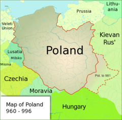
Image:Polska1020-c.png|{{en|Historical Map}}{{pl|Mapa historyczna}} |
Image:Polska1020-c.png|{{en|Historical Map}}{{pl|Mapa historyczna}} |
||
Image:Poland1020-c.png|{{en|Historical Map}}{{pl|Mapa historyczna}} |
Image:Poland1020-c.png|{{en|Historical Map}}{{pl|Mapa historyczna}} |
||
|{{en|Historical Map}}{{pl|Mapa historyczna}} |
|||
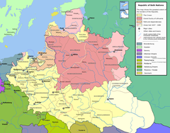
Image:Mon Henrykow Slaskich (1201-1241).png|Poland 1201-1241 |
Image:Mon Henrykow Slaskich (1201-1241).png|Poland 1201-1241 |
||
Image:Polska za W Lokietka (1275-1300).png|Poland 1275-1300 |
Image:Polska za W Lokietka (1275-1300).png|Poland 1275-1300 |
||
| Line 264: | Line 276: | ||
===Scandinavia=== |
===Scandinavia=== |
||
<gallery> |
<gallery> |
||
File:1593_map_of_Northern_Europe_by_Gerard_de_Jode.jpg|1593 |
|||
Image:Schweden_und_Norwegen_um_1888.jpg|Historical map of [[Sweden]] and [[Norway]] (1888) |
Image:Schweden_und_Norwegen_um_1888.jpg|Historical map of [[Sweden]] and [[Norway]] (1888) |
||
Image:Karte_der_Umgebung_von_Kopenhagen.jpg|Historical map of the area surrounding [[Copenhagen]] (1888) |
Image:Karte_der_Umgebung_von_Kopenhagen.jpg|Historical map of the area surrounding [[Copenhagen]] (1888) |
||
| Line 368: | Line 382: | ||
Image:Neukaledonien und Loyaltyinseln MKL1888.png|Historical map of New Caledonia and the Loyalty Islands |
Image:Neukaledonien und Loyaltyinseln MKL1888.png|Historical map of New Caledonia and the Loyalty Islands |
||
Image:NovaGuinea1600map.jpg|Spanish/Portuguese map ca.1600 of New Guinea and the Malay Archipelago |
Image:NovaGuinea1600map.jpg|Spanish/Portuguese map ca.1600 of New Guinea and the Malay Archipelago |
||
</gallery> |
|||
==Antarctica== |
|||
<gallery> |
|||
File:Kaart_van_Australië_en_Antartica,_objectnr_A_16194.tif |
|||
</gallery> |
</gallery> |
||
| Line 373: | Line 392: | ||
<gallery> |
<gallery> |
||
Image:Africa map 1508.png|Map of Africa (1508) |
Image:Africa map 1508.png|Map of Africa (1508) |
||
File:Afrique_de_la_mappemonde_Portugaise_anonyme_de_1502.jpg|1502 |
|||
Image:Africae tabula nova.jpg|Africae tabula nova (1570) |
Image:Africae tabula nova.jpg|Africae tabula nova (1570) |
||
Image:Africa1910s.jpg|Map of Africa (1910s) |
Image:Africa1910s.jpg|Map of Africa (1910s) |
||
| Line 385: | Line 405: | ||
Image:Gold_Coast_Map_1896.jpg|The Gold Coast and Ashanti Confederacy (1896) |
Image:Gold_Coast_Map_1896.jpg|The Gold Coast and Ashanti Confederacy (1896) |
||
Image:Příkopová propadlina východoafrická.jpg|Map of the Great Rift Valley (1931) |
Image:Příkopová propadlina východoafrická.jpg|Map of the Great Rift Valley (1931) |
||
File:Chart_of_South_Africa_and_Madagascar(GN01112).jpg |
|||
File:"Union_of_South_Africa",_by_Thos._Forman_%26_Sons,_Ltd.jpg |
|||
</gallery> |
</gallery> |
||
| Line 393: | Line 415: | ||
Image:Meyers_b16_s0570.jpg|Weather map for Europe (09. & 10 Dec 1887) |
Image:Meyers_b16_s0570.jpg|Weather map for Europe (09. & 10 Dec 1887) |
||
Image:Synoptic chart 1874.png|Synoptic chart of Europe and the North Atlantic, October 1874. |
Image:Synoptic chart 1874.png|Synoptic chart of Europe and the North Atlantic, October 1874. |
||
File:Cellarius_ptolemaic_systemFXD.jpg|astronomy |
|||
</gallery> |
</gallery> |
||
Latest revision as of 18:50, 28 November 2021
Old maps are included in the Wikimedia Atlas
.
World maps
[edit]-
-
-
World map of Waldseemüller, which first used the name America, 1507
-
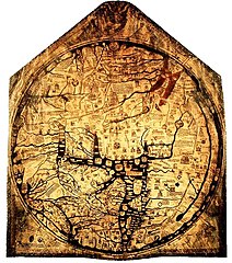
Ebstorfer world map
-
World map from the Middle Ages
-
Part of Tabula Peutingeriana
-
from Hartmann Schedels Worldchronic (1493)
-
World map by Johannes Kepler
-
-
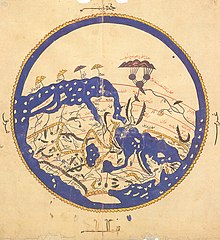
Al-Idrisi's world map
-
1503
-
1700
-
Laurent Fries world map, 1522
-
Pedro de Medina & G.B. Pedrazano, 1554
-
by Jacques de Vaux (1583)
-
Ortelius world map (1570)
-
Oronce Fine(1536)
-
by Samuel de Champlain (1567?-1635)
-
by Jean Guérard (1627)
-
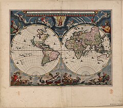
By Joan Blaeu (1664)
-
Magna Carta Mundi (1670)
-
Capt Dampier's new voyage to New Holland (1699)
-
Wang Jun Fu World Map (1680)
-
1690
-
-
by Philippe Buache (1737)
-
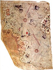
by Pîrî Reîs
-
1750 Japanese map
-
by Pîrî Reîs
-
Historical map of the international dateline
-
Antique World Map with magnetic declination by Leonhard Euler (1753)
-
(1902-1924)
-
1924
-
Map of Asia with Finnish text from "Pieni Tietosanakirja" (1925)
-
1932 artwork


See also
[edit]The Americas
[edit]-
Map of America by Sebastian Munster. 1561
-
Map of South America by Girolamo Ruscelli 1562
-
Map of America by Giovanni Battista Ramusio. 1565
-
Historical map of South America (1750)
-
Historical map of America. Ca. 1770
-
Historical map of the USA, Mexico and Central-America
-
Map of North and South America, French (18th century)
-
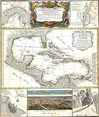
Mapa geographica completens Indiae Occidentalis


Caribbean and Central America
[edit]-
Barbados (1817)
-
Historical map of Central America (1860)
-
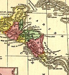
Historical map of Central America (1888)
-
Antilles. Map from the Brockhaus and Efron Encyclopedic Dictionary, 1890-1907
-
Historical map of the proposed Panama and Nicaragua canals


North America
[edit]-
Western part of the USA
-
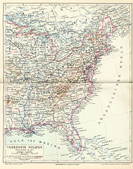
Eastern part of the USA
-
Captain Marcy's route though Texas (1854)
-
Oregon Trail (1907)
-
Historical map of the Hawaii-archipelago
-
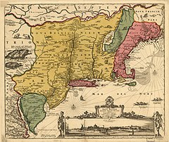
Map of New Netherland and New England (around 1685)
-
New Holland map by William Dampier (1699)
-
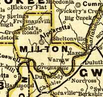
Milton County, Georgia (1883)
-
Cherokee lands (1822)
-
Cherokee counties (1834)
-
Elizabeth City County (1895)
-
Norfolk County, Virginia (1895)
-
Princess Anne County, Virginia (1895)
-
North America (1797)
-
Map of "Greater America" (1899)
-
by Claude Bernou (16..-17..?)
-
Nova Belgica et Anglia Nova (1635)photos
-
rail map
-
1936 clippers


South America
[edit]-
Map of Peru by Abraham Ortelius, 1608.
-
Historical map of Peru (1635)
-
Map of Peru. (1647). By Ioannem Ianssonium. (1558-1664).
-
Map of Peru by Nicolas Sanson d'Abbeville (1600-1667)
-
Map of Peru and the Amazonas River by Nicolas Sanson d'Abbeville (1600-1667)
-
Map of Peru by Nicolas Sanson d'Abbeville (1600-1667)
-
Map of Peru. 1683. French version
-
Map of Peru. 1683. Das Königreich Perou
-
Historical map of Peru by Herman Moll. Ca. 1720
-
Historical map of Peru by Emanuel Bowen. Ca. 1750
-
Historical map of Peru by Benard. Ca. 1750
-
Historical map of Peru by Rigobert Bonne. Ca. 1780
-
Historical map of South America by Diogo Homem. Ca 1558


Europe
[edit]-
Leo Belgicus - map of the Low Countries (1611)
-
Leo Belgicus by P. Kaerius & Hendrik Floris van Langren (1617)
-
Historical map of the Bay of Bajä (1888)
-
Historical map of the Stait of Messina (1888)
-
Historical map of Cyprus (1888)
-
Historical map of Madeira (1888)
-
Historical map of the Balkan peninsula (1888)
-
Historical map of the Balkans War Theatre during the First Balkan War (1912-13)
-
Historical map of the Kingdom of Hungary (1888)
-
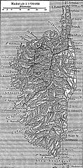
Historical map of the Isle of Corsica (1888)
-
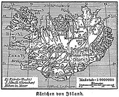
Historical map of Iceland (1888)
-
Straßenkarte für Rompilger (Erhard Etzlaub, um 1500)
-
Historical map of the area surrounding Toulon (1888)
-
Europe at the death of Charlemagne in 814
-
Eastern Europe (1836)
-
Historical map of Switzerland 1291-1515 (1912)
-
Historical map of Switzerland 1291-1515 (1912)
[technical revised version] -
Ottoman Empire, 1481-1683 (1923)
-
Carniola before 1900
-
Route of the leaders of the first Crusade (1911)
-
The Zeno Map (1558)
-
Carte ancienne de la Nouvelle-Zemble
-
Map of Europe with Finnish text from "Pieni Tietosanakirja" (1925)
-
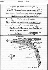
Canary Islands map by William Dampier (1699)
-
French picture map


![Historical map of Switzerland 1291-1515 (1912) [technical revised version]](https://upload.wikimedia.org/wikipedia/commons/thumb/2/2f/Swiss-confederation-shepherd-atlas_1-2245x1259.jpg/240px-Swiss-confederation-shepherd-atlas_1-2245x1259.jpg)


Austria
[edit]-
Karte Oberösterreichs. Archiducatus Austriae Superioris Descriptio facta Anno 1667. Georg Matthäus Vischer, erschienen 1669
-
Historical map of the area surrounding Bad Ischl (1888)
-
Historical map of the area surrounding Innsbruck (1888)
-
Historical map of the area surrounding Vienna (1888)
-
Historical map of Tyrol
-
Historische Karte des oberösterreichischen Innviertels (1779)


Bulgaria
[edit]-
Atlas sive Cosmographicae Meditationes de Fabrica Mundi et Fabricati Fugura
-
Imperii Orientalis et Circumjacentium Regionum, sub Constantino Porphyrogenito et ejus praedecessoribus descriptio. (Paris : Guillelmo Del'Isle, 1715?).
-
Map of railway lines of Bulgaria (1877-1878)
-
A map of the Principality of Bulgaria and Eastern Rumelia before the unification of Bulgaria in 1885. The map is from an 1882 atlas
-
Mapa del principado de Bulgaria tras 1885, con la anexión de Rumelia oriental
-
Map of Bulgaria (1885)
-
Ethnic map of Bulgaria, according to the census from 1892
-
Bulgarien, alte Schulkarte; um 1922
-
Bulgaria during World War I
-
Map of National costume of Bulgaria


Czech Republic
[edit]-
Historical map of Great Moravia under the rule of Svatopluk
-
Historical map of the Czech state in the 10th century under the rule of Boleslav I. and Boleslav II.
-
Historical map of the Czech Lands and other lands ruled by the King of Bohemia (turn of the 14th century)
-
Historical map of the Kingdom of Bohemia during the Hussite Wars (1419-34)
-
Historical map of the Czech Lands (14th century - 1742)
-
Historical map of the Czech Lands and other lands ruled by the King of Bohemia (reign of John of Bohemia)
-
Historical map of the Czech Lands and other lands ruled by the King of Bohemia (second half of the 14th century)
-
Historical map of the Czech Lands and other lands ruled by the King of Bohemia (beginning of the Thirty Years War)
-
Historical map of the Czech Lands as a part of the Habsburg ruled territories (16th century)
-
Historical map of the Czech Lands (from the half of the 18th century to the First World War)
-
Historical map of the Czech Lands (1892)
-
Historical map of the Czech lands and Slovakia (published in exile magazine La Nation Tchèque during the First World War)
-
Historical map of the Czech lands within the first Czechoslovak Republic in 1919 (published in Czech daily 'Svornost' in Chicago)
-
Historical map of the Czech lands within the first Czechoslovak Republic until 1928 (in 1928 Moravia and Czech Silesia were merged into one administrative unit - the Moravian-Silesian Land)


France
[edit]Germany
[edit]-
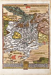
Magna Germania um 150 n. Chr. Kopie bzw. Rekonstruktion von Nicolaus Germanus (15. Jahrhundert) nach dem Text des Ptolemäus.
-
Grafschaft Mark (1681)
-
Upper Silesia (1746)
-
Grafschaft Mark (1791)
-
Harburg von 1757
-
Oberamt Ravensburg (1834)
-
Historical geological map of Thuringia (1888)
-
Historical map of the area surrounding Wiesbaden (1888)
-
Historical map of the area surrounding Stuttgart (1888)
-
Historical map of the Kiel Canal (1888)
-
Historical map of Württemberg and Hohenzollern (1888)
-
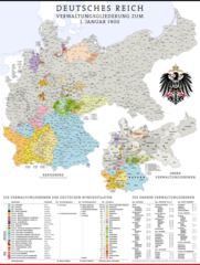
Administrative map of the German Empire (1900)
-
Historical map of Brandenburg (1903)
-
Historical map of Westphalia (1888)
-
Historical map of Heligoland (1888)
-
Historical map of the area surrounding Kiel
-
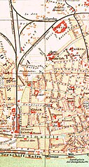
Historical map of the area surrounding Potsdam
-
Historical map of the German Empire: General industry, mines and smelting industry
-
Historical map, Population density 1881
-
Historical map of the German Empire: Population density
-
Historical map of the German Empire: Historical maps 1
-
Historical map of the German Empire: Historical maps 2
-
Historical map, Religions 1881
-
Historical map of the German Empire: Religious denomination
-
Ancient Germania (1849)
-
Historical map of the German Empire: Agriculture
-
Historical map of the German Empire: Political map
-
Historical map of Prussia, before 1905
-
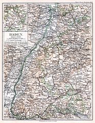
Baden before 1900
-
Rheinisch-Westfälischs Kohlen- und Industriegebiet (1886)
-
Province Saxony before 1918
-
Map of a part of North Rhine-Westphalia, (early 19th century) showing Ratingen, Wuppertal, Mülheim, Essen and Bochum
-
-
Map of a part of Hamburg (Altona)
-
Historical map of territorial losses (the areas in black) of Germany after the 1919 Treaty of Versailles


See also
[edit]Italy
[edit]-
Historical map of area surrounding Bozen (1888)
-
Historical map of area surrounding Meran (1888)
-
Historical map of the Isle of Capri (1888)
-
Historical map of the Isle of Sardinia (1888)
-
Historical map of La Spezia (1888)
-
Historical map of Trieste (1888)


See also
[edit]Poland
[edit]-
Upper Silesia (1746)
-
Western Governorships (of Russian Empire) and Polish Kingdom in 1902
-
English: Hydrography of PolandPolski: Hydrografia Polski
-
English: Historical MapPolski: Mapa historyczna
-
English: Historical MapPolski: Mapa historyczna
-
English: Historical MapPolski: Mapa historyczna
-
English: Historical MapPolski: Mapa historyczna
-
English: Historical MapPolski: Mapa historyczna
-
English: Historical MapPolski: Mapa historyczna
-
English: Historical MapPolski: Mapa historyczna
-
English: Historical MapPolski: Mapa historyczna
-
Poland 1201-1241
-
Poland 1275-1300
-
Poland 1304-1333
-
Polish-Lithuanian Commonwealth in 17th and 18th century
-
Polish-Lithuanian Commonwealth - administrative division
-
Poland in 1939
-
Poland between 1921 and 1939


Russia
[edit]-
Historical map of Russia (1725)
-
Historical map of the European part of Russia (1888)
-
Historical map of the Grand Duchy of Moscow (1888)
-
Historical map of the area surrounding St. Petersburg (1888)
-
Historical map of Russia
-
Historical map of Vladivostok when seized by the Czechoslovak Legions (29 June 1918)


Scandinavia
[edit]-
1593
-
-
Historical map of the area surrounding Copenhagen (1888)
-
Historical map of the area surrounding Stockholm (1888)


Slovakia
[edit]-
Historical map of Slovakia (1921)
-
New railways in Slovakia (1932)
-
Historical map of the Upper Váh Basin (1933)


Iberian Peninsula (Spain and Portugal)
[edit]-
-
Historical map of Spain (1850)
-


Turkey
[edit]-
History map of European Turkey
-
Historical map of the Bosporus


Gibraltar
[edit]-
Historical map of the promontory of Gibraltar (1888)

UK
[edit]-
Map of the County of Northumberland by Christopher & John Greenwood (1828)
-
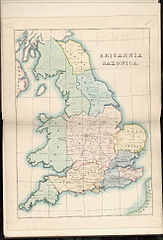
Britannia Saxonica (1833)
-
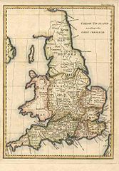
Saxon England according to the Saxon Chronicle (1830)
-
Britannia Saxonica (1695)


see also
[edit]Category:Old Ordnance Survey map images
Middle East
[edit]-
Map of the empire of Alexander the Great
-
Hartmann Schedel: DESTRVCCIO IHEROSOLIME (from the Liber cronicarum, Nuremberg 1493)
-
The oldest printed prospect of Jerusalem - By Hartmann Schedel, Nürnberg 1493 (from the Liber cronicarum)


Asia
[edit]-
Historical map of Central Asia
-
Historical map of the Crimean peninsula (1888)
-
Historical map of Ceylon (Sri Lanka) (1888)
-
map of "Hindoostan" by Arrowsmith and Lewis (1812)
-
Tonking, Östl. Hinterindien, Hue, Ha-Noi
-
Map of French Indochina after the First World War
-
Political map of India after the First World War
-
Ethnographical map of High Asia in the beginning of 20th century
-
Old map of major glaciers of the Tian Shan
-
Map of railways in West Asia in the beginning of 20th century


China
[edit]-
Chinese Empire (aka Qing Dynasty), 1892, from the Encyclopædia Britannica North American edition
-
Political map of China after the First World War


Indonesia
[edit]


Japan
[edit]-
map on 18th century
-
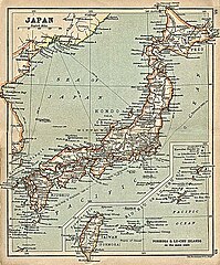
map on 1911

Korea
[edit]Taiwan
[edit]-
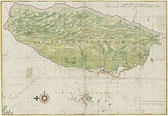
The first 'correct' map of Taiwan in the world, which was drawn by a Dutch sailor (1625)
-
The Island Formosa and the Pescadores by Johannes Vingboons (ca 1640)
-
Historical map of Taiwan (1896)


Ryukyu
[edit]Oceania
[edit]Melanesia
[edit]-
Historical map of New Caledonia and the Loyalty Islands
-
Spanish/Portuguese map ca.1600 of New Guinea and the Malay Archipelago


Antarctica
[edit]
Africa
[edit]-
Map of Africa (1508)
-
1502
-
Africae tabula nova (1570)
-
Map of Africa (1910s)
-
Map of Africa (1890)
-
Map of Africa (1812)
-
Map of Eastern Africa (1829)
-
Historical map of Zanzibar (1888)
-
Historical map of Cameroun
-
Historical map of Madagascar (1888)
-
Historical map of the gulf of Aden (1888)
-
The Gold Coast and Ashanti Confederacy (1896)
-
Map of the Great Rift Valley (1931)
-
-


Special maps
[edit]-
Language world map (1888)
-
Declination world map (1888)
-
Weather map for Europe (09. & 10 Dec 1887)
-
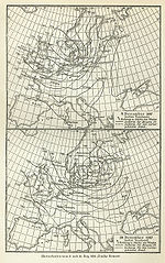
Synoptic chart of Europe and the North Atlantic, October 1874.
-
astronomy


War maps
[edit]-
Historical map of the campaign by Breitenfeld (17.09.1631)
-
Historical map of the campaign by Lützen (16.11.1632)
-
Historical map of the campaign by Fehrbellin (28.06.1675)
-
Historical map of the campaign by Höchstädt (13.08.1704)
-
Historical map of the campaign by Hohenfriedeberg (04.06.1745)
-
Historical map of the campaign by Kolin (18.06.1757)
-
Historical map of the campaign by Roßbach(05.11.1757)
-
Historical map of the campaign by Leuthen(05.12.1757)
-
Historical map of the campaign by Hochkirch (14.10.1758)
-
Historical map of the campaign by Kunersdorf (12.08.1759)
-
Mannheim (1794)
-
Battle of Marengo (1800)
-
Historical map of the campaign by Austerlitz (02.12.1805)
-
Historical map of the campaign by Jena (14.10.1806)
-
Historical map of the campaign by Auerstädt (14.10.1806)
-
Historical map of the campaign by Aspern (12.05.1809)
-
Historical map of the campaign by Wagram (05. & 06.07.1809)
-
Historical map of the battle of the nations by Leipzig (16.10.1813)
-
Historical map of the battle of the nations by Leipzig (18.10.1813)
-
Historical map of the campaign by Waterloo (18.06.1815)
-
Historical map of the siege of Sevastopol (1854-1855)
-
Historical map of the campaign by Solferino (24.06.1859)
-
Battle of Pea Ridge (1862)
-
Historical map of the campaign by Königgrätz (03.07.1866)
-
Historical map of the campaign by Wörth(06.08.1870)
-
Historical map of the campaign by Sedan (01.09.1870)
-
Historical map of the campaign by Orléans (Dec 1870)
-
Historical map of the campaign by Plewen (11. & 12.09.1877)


