Category:Mount Whitney
Vai alla navigazione
Vai alla ricerca
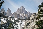
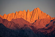
English: Mount Whitney (14,505 feet or 4,421 metres) the highest point in the Contiguous United States.
Español: Monte Whitney — Sierra Nevada, California.
monte più alto della California | |||||
| Carica un file multimediale | |||||
| Istanza di | |||||
|---|---|---|---|---|---|
| Parte di |
| ||||
| Prende il nome da |
| ||||
| Materiale usato | |||||
| Area protetta |
| ||||
| Luogo |
| ||||
| Evento significativo |
| ||||
| Catena montuosa | |||||
| Prominenza topografica |
| ||||
| Isolamento topografico |
| ||||
| Via d'arrampicata | |||||
| Altezza sul mare |
| ||||
| Montagna principale | |||||
 | |||||
Sottocategorie
Questa categoria contiene le 2 sottocategorie indicate di seguito, su un totale di 2.
S
W
Pagine nella categoria "Mount Whitney"
Questa categoria contiene un'unica pagina, indicata di seguito.
File nella categoria "Mount Whitney"
Questa categoria contiene 129 file, indicati di seguito, su un totale di 129.
-
A346, from summit of Mount Whitney, California, USA, 2011.JPG 1 024 × 683; 417 KB
-
Alabama Hills under Mt. Whitney.jpg 3 840 × 2 160; 2,73 MB
-
Alabama Hills with Mount Whitney in background.JPG 3 712 × 1 493; 2,31 MB
-
Barren scape between Forester Pass and Mt. Whitney (4896501137).jpg 2 592 × 1 936; 3,25 MB
-
Western Landscape, Mount Whitney by Albert Bierstadt.jpg 956 × 640; 135 KB
-
Breeder and sportsman (1893) (20222714329).jpg 2 036 × 1 250; 1,18 MB
-
California - Mt. Whitney - NARA - 23934643.jpg 3 656 × 2 880; 1,49 MB
-
California - Mt. Whitney - NARA - 23934645.jpg 3 656 × 2 880; 1,77 MB
-
California - Mt. Whitney - NARA - 23934647.jpg 3 656 × 2 880; 1,67 MB
-
California - Mt. Whitney - NARA - 23934649.jpg 3 656 × 2 880; 2,14 MB
-
California - Mt. Whitney - NARA - 23934651.jpg 3 656 × 2 880; 1,98 MB
-
California - Mt. Whitney - NARA - 23934653.jpg 3 656 × 2 880; 2 MB
-
California - Mt. Whitney - NARA - 23934655.jpg 3 656 × 2 880; 2,28 MB
-
California - Mt. Whitney - NARA - 23934657.jpg 3 656 × 2 880; 2,19 MB
-
California - Mt. Whitney - NARA - 23934659.jpg 3 288 × 2 840; 1,98 MB
-
California a guide to the Golden state - Mt Whitney, from Whitney portal.jpg 2 586 × 3 486; 3,88 MB
-
California National Guard - 48650425808.jpg 4 032 × 3 024; 2,78 MB
-
California National Guard - 48650785161.jpg 4 032 × 3 024; 3,29 MB
-
Camping at Upper Boyscout Lake.jpg 900 × 675; 282 KB
-
Consultation Lake, 5.jpg 4 000 × 3 000; 3,37 MB
-
Cya later, Mt. Whitney - Flickr - daveynin.jpg 3 456 × 2 304; 2,82 MB
-
Dark Amphibole Crystals in Rock from near Mount Whitney in California.jpg 3 072 × 2 304; 2,22 MB
-
Dodecatheon redolens (Primula fragrans), Mount Whitney.jpg 2 048 × 1 615; 902 KB
-
DSC 3810b - Flickr - Clinton Steeds.jpg 3 008 × 2 000; 2,58 MB
-
East Face Mount Whitney.jpg 1 281 × 1 461; 476 KB
-
Eastern Sierra with Mount Whitney.jpg 2 688 × 1 425; 955 KB
-
FMIB 39575 Whitney Creek as it enters Crabtree Meadow.jpeg 571 × 789; 128 KB
-
Good Morning from Mount Whitney (Unsplash).jpg 5 184 × 3 456; 10,72 MB
-
Hiding in Plain Sight, Mt. Whitney, CA 9-16 (30945615716).jpg 3 204 × 2 274; 3,15 MB
-
Hiding Mt Whitney, Lone Pine, CA 5-19-15 (18807490710).jpg 2 800 × 1 915; 1,66 MB
-
High Camp.jpg 2 048 × 1 536; 686 KB
-
Highs and lows in California.jpg 2 149 × 2 149; 797 KB
-
Hiking - Riding - California - DPLA - 17c71a6de3759e5a7da4608946ef306c.jpg 4 725 × 3 846; 2,93 MB
-
Lee on Mt. Whitney Trail2 (14531693759).jpg 2 048 × 1 536; 576 KB
-
Lee Roeser on Mt. Whitney Trail (14738209393).jpg 4 000 × 3 000; 3,87 MB
-
Lone Pine Peak and Mount Whitney.jpg 1 005 × 850; 978 KB
-
Marmots Eating Trash.jpg 2 489 × 1 961; 1,96 MB
-
Me and Dominoe below Mt Whitney (3186132885).png 733 × 537; 804 KB
-
Mount Whitney (28614888246).jpg 2 000 × 1 625; 1,81 MB
-
Mount Whitney (3027967483).jpg 3 872 × 2 592; 4,61 MB
-
Mount Whitney (4 421 m) from Highway to Onion Valley.jpg 2 592 × 1 944; 2,4 MB
-
Mount Whitney (4 421 m) from U.S. Route 395.jpg 2 592 × 1 944; 2,4 MB
-
Mount Whitney - panoramio.jpg 2 048 × 1 536; 1,03 MB
-
Mount Whitney 2003-03-25.jpg 1 536 × 1 024; 1,54 MB
-
Mount Whitney 3D map version1.jpg 1 136 × 786; 626 KB
-
Mount Whitney 3D version 1.gif 450 × 321; 19,79 MB
-
Mount Whitney behind Owens Valley.jpg 3 872 × 2 592; 3,46 MB
-
Mount Whitney from Flight Over Death Valley National Park, California (15516641509).jpg 4 000 × 3 000; 3,03 MB
-
Mount Whitney from Flight Over Death Valley National Park, California (15678789386).jpg 4 000 × 3 000; 2,54 MB
-
Mount Whitney from Highway to Onion Valley.jpg 2 592 × 1 944; 2,41 MB
-
Mount Whitney from Route to Onion Valley.jpg 2 592 × 1 944; 2,32 MB
-
Mount Whitney from south.jpg 2 048 × 1 373; 550 KB
-
Mount Whitney from U.S. Route 395.jpg 2 592 × 1 944; 2,41 MB
-
Mount Whitney landscape.jpg 4 928 × 3 264; 1,51 MB
-
Mount Whitney plaque.JPG 3 072 × 2 304; 1,3 MB
-
Mount Whitney September 2009.JPG 3 072 × 2 304; 4,88 MB
-
Mount Whitney Trail Cables.JPG 3 072 × 2 304; 2,2 MB
-
Mount Whitney Trail Switchbacks.JPG 3 072 × 2 304; 2,88 MB
-
Mount Whitney Trailhead - Flickr - daveynin.jpg 3 456 × 2 304; 3,7 MB
-
Mount Whitney Wikivoyage banner.jpg 3 027 × 432; 1,14 MB
-
Mount Whitney, east face, from Trail Camp, Sept. 17, 2014 - panoramio.jpg 4 128 × 2 322; 2,56 MB
-
Mount Whitney, Touching the Clouds - Flickr - kla4067.jpg 4 837 × 3 338; 5,16 MB
-
Mt Muir, base at 12000 feet - 360 Pano.jpg 25 000 × 5 622; 43,73 MB
-
Mt Whitney from Alabama Hills-wideshot.jpg 1 140 × 580; 119 KB
-
Mt Whitney from Alabama Hills2.jpg 611 × 369; 33 KB
-
Mt Whitney Hiding, Sierra Nevada Range, CA 5-15 (31261902991).jpg 3 349 × 1 628; 1,48 MB
-
Mt Whitney in Clouds, CA 5-19-50 (18750645566).jpg 2 800 × 2 101; 1,37 MB
-
Mt Whitney Panorama, Lone Pine, CA 2016 (32615691172).jpg 3 459 × 1 779; 2,4 MB
-
Mt Whitney Panorama, Sierra Nevada, CA 6-16 (27683394770).jpg 2 800 × 817; 976 KB
-
Mt Whitney Range, Sierra Nevada, CA 6-16 (27783228620).jpg 2 800 × 1 742; 1,64 MB
-
Mt Whitney Reflection and Heron, CA 6-21-16 (27821936475).jpg 2 800 × 2 100; 1,93 MB
-
Mt Whitney, CA 6-20-16a (27841986865).jpg 2 800 × 2 100; 2,46 MB
-
Mt Whitney, Highest in the Lower 48, CA 9-16 (30306110865).jpg 2 450 × 1 371; 1,67 MB
-
Mt Whitney, Tallest in Lower Forty-eight, CA 2016.jpg 2 706 × 1 546; 1,86 MB
-
Mt. Whitney and south-eastern Sierra Nevada aerial.jpg 2 320 × 1 352; 820 KB
-
Mt. Whitney, CA 2016 (28893679930).jpg 3 312 × 2 456; 3,57 MB
-
Mt. Whitney, California 1999 (6309693707).jpg 1 464 × 986; 409 KB
-
Mt. Whitney, Lone Pine, USA (Unsplash).jpg 4 240 × 2 832; 10,79 MB
-
Mt. Whitneys Claws Talons at Sunset (4897103718).jpg 2 592 × 1 936; 2,6 MB
-
MtWhitney.png 3 840 × 2 160; 5,63 MB
-
Panorama of Mt. Whitney.jpg 22 080 × 1 680; 8,31 MB
-
PSM V52 D630 Mount whitney from lone pine canyon.jpg 1 703 × 1 113; 352 KB
-
Sequoia National Park 03 Topography.png 7 680 × 4 320; 40,81 MB
-
Sierra Nevada Banner.jpg 3 456 × 494; 535 KB
-
Sierra Nevada Mt Whitney 02.png 3 840 × 2 160; 5,39 MB
-
Sierra nevada schematic.png 800 × 512; 22 KB
-
Southern Sierra.jpg 710 × 473; 222 KB
-
Sun Flares from Mt. Whitney towards Guitar Lake (4896504807).jpg 2 592 × 1 936; 2,13 MB
-
Sunrise at Diaz Lake, Sierra Nevada, CA 2016 (28862575496).jpg 2 800 × 1 933; 2,77 MB
-
Sunrise at Mt. Whitney - Flickr - d.catch.jpg 5 212 × 3 468; 11,26 MB
-
Sunrise on Lake Diaz, Serra Nevada, CA 6-16 (28171971920).jpg 3 555 × 1 924; 2,34 MB
-
Sunset At Mt Whitney (128332695).jpeg 2 048 × 1 367; 1,08 MB
-
Thor Peak, Mount Whitney.jpg 2 659 × 1 592; 1 014 KB
-
Trail Crest on Mount Whitney trail.jpg 2 272 × 1 704; 1,62 MB
-
Trail Crest Panorama.jpeg 1 600 × 387; 156 KB
-
Trail Crest Sign.JPG 1 600 × 1 200; 235 KB
-
Ukraine flag on Mount Whitney.JPG 4 128 × 2 322; 3,88 MB
-
Lone Pine Peak (links) 3945m en Mount Whitney 4421m (centraal) - 8-10-2012 14-09-42.jpg 4 285 × 2 413; 7,58 MB
-
View of Mt. Whitney from Lone Pine, CA.jpg 6 016 × 4 000; 2,25 MB
-
Views from Mt. Whitney (4897099432).jpg 2 592 × 1 936; 2,5 MB
-
Whitney (6183481656).jpg 2 560 × 1 707; 3,7 MB
-
Whitney Climbers 1931.jpg 662 × 510; 52 KB
-
Whitney East Face.jpg 400 × 266; 67 KB
-
Whitney Needles.jpg 800 × 600; 257 KB
-
Whitney Portal Road and Mt. Whitney - Flickr - daveynin.jpg 2 304 × 3 456; 2,62 MB
-
Whitney Portal Road line can be seen front from us - Flickr - daveynin.jpg 3 456 × 2 304; 3,06 MB
-
Whitney Portal Road.jpg 2 304 × 3 072; 2,52 MB
-
Whitney Portal, Mt Whitney, CA 99 (33313944141).jpg 1 800 × 1 212; 789 KB
-
Whitney trail at night.jpg 2 400 × 1 600; 4,11 MB
-
Whitney Trail Switchbacks.jpg 1 200 × 1 600; 469 KB
-
Whitney's October season - Flickr - daveynin.jpg 3 456 × 2 304; 3,47 MB
-
Whitney-icy-trail.jpg 604 × 411; 54 KB
-
Whitney-Zone1000px.jpg 1 000 × 897; 734 KB
-
WhitneyAlbertBierstadt.jpeg 489 × 283; 49 KB
-
WhitneyPlaque.JPG 930 × 697; 104 KB
-
Ivesia lycopodioides.jpg 4 608 × 3 456; 4,61 MB
-
A347, Skypilot near summit of Mount Whitney, California, USA, 2011.JPG 800 × 534; 184 KB
-
FMIB 39559 Cliffs south of Langley's Camp, base of Mount Whitney.jpeg 959 × 511; 159 KB
-
Sky Pilot (Polemonium eximium).jpg 1 600 × 1 200; 262 KB
Categorie:
- Mountains of the Sierra Nevada (California)
- John Muir Wilderness
- 4420s mountains of the United States
- Visitor attractions in California
- Mountains of Inyo County, California
- Mountains named after people
- Highest points of U.S. states
- Highest points of national parks of the United States
- Whitney Granodiorite
- Mountains of Tulare County, California


