هنلی-آن-تیمز: نوسخهلر آراسینداکی فرق
محتوای حذفشده محتوای افزودهشده
4321bot (دانیشیق | چالیشمالار) ک ←top |
4321bot (دانیشیق | چالیشمالار) ک گؤرونتولر, removed: @20@ |
||
| خط ۱: | خط ۱: | ||
{{Infobox UK place|official_name= Henley-on-Thames|static_image_name = Town Hall, Henley - geograph.org.uk - 36320.jpg|static_image_caption = Town hall and market place |coordinates = {{coord|51.536|-0.898|display=inline,title}}|os_grid_reference= SU7682|label_position= left|london_distance= {{convert|36|mi}}|area_total_km2=5.58|population= 11619|population_ref= ([[United Kingdom Census 2011|2011 Census]])|civil_parish= Henley-on-Thames|shire_district= [[South Oxfordshire]]|shire_county= [[Oxfordshire]]|region= South East England|country= England|post_town= Henley-on-Thames|postcode_district=RG9|postcode_area=RG|dial_code= 01491|constituency_westminster= [[Henley (UK Parliament constituency)|Henley]]|website= [http://www.henleytowncouncil.gov.uk/ Henley-on-Thames Town Council]}} |
{{Infobox UK place|official_name= Henley-on-Thames|static_image_name = Town Hall, Henley - geograph.org.uk - 36320.jpg|static_image_caption = Town hall and market place |coordinates = {{coord|51.536|-0.898|display=inline,title}}|os_grid_reference= SU7682|label_position= left|london_distance= {{convert|36|mi}}|area_total_km2=5.58|population= 11619|population_ref= ([[United Kingdom Census 2011|2011 Census]])|civil_parish= Henley-on-Thames|shire_district= [[South Oxfordshire]]|shire_county= [[Oxfordshire]]|region= South East England|country= England|post_town= Henley-on-Thames|postcode_district=RG9|postcode_area=RG|dial_code= 01491|constituency_westminster= [[Henley (UK Parliament constituency)|Henley]]|website= [http://www.henleytowncouncil.gov.uk/ Henley-on-Thames Town Council]}} |
||
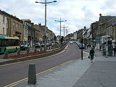
هنلی-آن-تیمز ([[اینگیلیس دیلی|اینگیلیسیجه]]: Henley-on-Thames) [[بؤیوک بریتانیا|بریتانیا]]دا بیر یاشاییش منطقهسیدیر سوْن نۆفوس تخمینلرینه گؤره 11619 نفر دیر. بۇ شهر [[اینگیلیس]] اؤلکهسینده یئرلشیب. |
'''هنلی-آن-تیمز''' ([[اینگیلیس دیلی|اینگیلیسیجه]]: Henley-on-Thames) [[بؤیوک بریتانیا|بریتانیا]]دا بیر یاشاییش منطقهسیدیر سوْن نۆفوس تخمینلرینه گؤره 11619 نفر دیر. بۇ شهر [[اینگیلیس]] اؤلکهسینده یئرلشیب. |
||
== گؤرونتولر == |
|||
<gallery> |
|||
Image:lanark01.jpg |
|||
Image:lanark00.jpg |
|||
Image:Kyoto gardens Holland park.jpg |
|||
Image:Kyoto Garden Holland Park London 6662 pano 3.jpg |
|||
Image:KScloisters-GerryMillar.jpg |
|||
Image:Kingswoodclocktower.JPG |
|||
Image:Kingswoodchurch.JPG |
|||
</gallery> |
|||
== بیرده باخ == |
|||
[[بریتانیا شهرلرین لیستی]] |
|||
== قایناقلار == |
|||
{{قایناق}} |
|||
{{شهر-قارالاما}} |
|||
{{Authority control}} |
|||
[[بؤلمه:بریتانیا شهرلری]] |
|||
[[en:Henley-on-Thames]] |
[[en:Henley-on-Thames]] |
||
۲۰ مئی ۲۰۱۸، ساعت ۰۴:۲۸ نوسخهسی
| Henley-on-Thames | |
|---|---|
 Town hall and market place | |
 Henley-on-Thames Location within | |
| Area | ۵٫۵۸ km2 (۲٫۱۵ sq mi) |
| جمعیت | ۱۱٬۶۱۹ (2011 Census) |
| • Density | ۲٬۰۸۲/km2 (۵٬۳۹۰/sq mi) |
| OS grid reference | SU7682 |
| • لندن | ۳۶ mile (۵۸ km) |
| Civil parish |
|
| District | |
| Shire county | |
| Region | |
| اؤلکه | England |
| موستقیل دوولت | United Kingdom |
| Post town | Henley-on-Thames |
| Postcode district | RG9 |
| تیلفون کودو | 01491 |
| UK Parliament | |
| Website | Henley-on-Thames Town Council |
هنلی-آن-تیمز (اینگیلیسیجه: Henley-on-Thames) بریتانیادا بیر یاشاییش منطقهسیدیر سوْن نۆفوس تخمینلرینه گؤره 11619 نفر دیر. بۇ شهر اینگیلیس اؤلکهسینده یئرلشیب.
گؤرونتولر


بیرده باخ
قایناقلار
| بو شهرلر ایله باغلی مقاله، بیر قارالاما مقاله دیر. بونو گئنیشلندیرمکله ویکیپدیایا کؤمک ائده بیلرسینیز. |
| International | |
|---|---|
| National | |
| Geographic | |